You are here: Home > Network List > IU - Global Seismograph Network (GSN - IRIS/USGS) Stations List
> Station RSSD Black Hills, South Dakota, USA > Earthquake Result Viewer
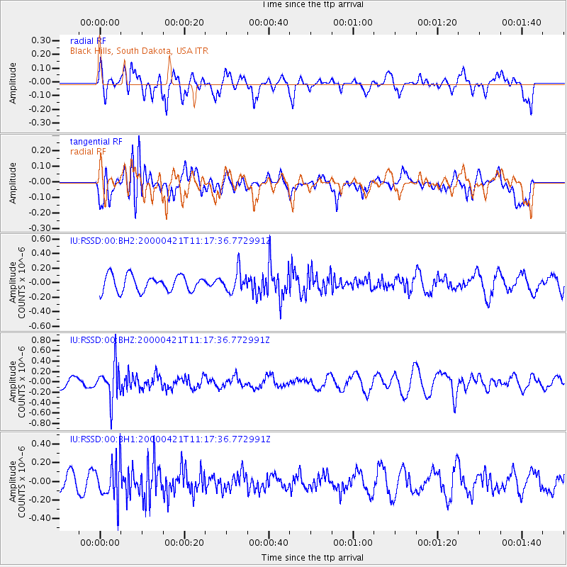
RSSD Black Hills, South Dakota, USA - Earthquake Result Viewer
*The percent match for this event was below the threshold and hence no stack was calculated.
| Earthquake location: |
Western Honshu, Japan |
| Earthquake latitude/longitude: |
35.7/135.5 |
| Earthquake time(UTC): |
2000/04/21 (112) 11:06:16 GMT |
| Earthquake Depth: |
346 km |
| Earthquake Magnitude: |
5.4 MB, 5.5 MW, 5.4 MW |
| Earthquake Catalog/Contributor: |
WHDF/NEIC |
|
| Network: |
IU Global Seismograph Network (GSN - IRIS/USGS) |
| Station: |
RSSD Black Hills, South Dakota, USA |
| Lat/Lon: |
44.12 N/104.04 W |
| Elevation: |
2060 m |
|
| Distance: |
84.0 deg |
| Az: |
38.621 deg |
| Baz: |
315.116 deg |
| Ray Param: |
$rayparam |
*The percent match for this event was below the threshold and hence was not used in the summary stack. |
|
| Radial Match: |
47.72206 % |
| Radial Bump: |
400 |
| Transverse Match: |
33.628506 % |
| Transverse Bump: |
400 |
| SOD ConfigId: |
590571 |
| Insert Time: |
2013-09-24 18:09:58.108 +0000 |
| GWidth: |
2.5 |
| Max Bumps: |
400 |
| Tol: |
0.001 |
|
Signal To Noise
| Channel | StoN | STA | LTA |
| IU:RSSD:00:BHZ:20000421T11:17:36.772991Z | 2.7524676 | 3.3600054E-7 | 1.2207248E-7 |
| IU:RSSD:00:BH1:20000421T11:17:36.772991Z | 2.111921 | 1.9982811E-7 | 9.461911E-8 |
| IU:RSSD:00:BH2:20000421T11:17:36.772991Z | 1.3517694 | 1.4758226E-7 | 1.0917709E-7 |
| Arrivals |
| Ps | |
| PpPs | |
| PsPs/PpSs | |


