You are here: Home > Network List > TA - USArray Transportable Network (new EarthScope stations) Stations List
> Station G59A Clarenceville, QC, USA > Earthquake Result Viewer
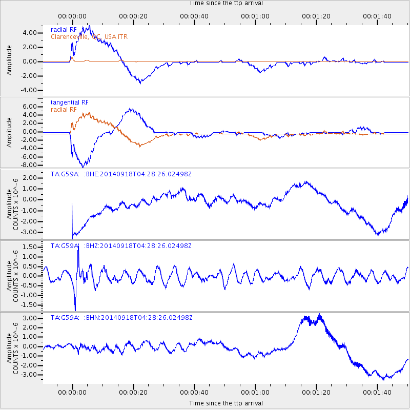
G59A Clarenceville, QC, USA - Earthquake Result Viewer
*The percent match for this event was below the threshold and hence no stack was calculated.
| Earthquake location: |
Northwest Of Kuril Islands |
| Earthquake latitude/longitude: |
50.6/150.2 |
| Earthquake time(UTC): |
2014/09/18 (261) 04:17:53 GMT |
| Earthquake Depth: |
502 km |
| Earthquake Magnitude: |
5.6 MW |
| Earthquake Catalog/Contributor: |
ISC/ISC |
|
| Network: |
TA USArray Transportable Network (new EarthScope stations) |
| Station: |
G59A Clarenceville, QC, USA |
| Lat/Lon: |
45.08 N/73.18 W |
| Elevation: |
36 m |
|
| Distance: |
77.6 deg |
| Az: |
29.871 deg |
| Baz: |
333.368 deg |
| Ray Param: |
$rayparam |
*The percent match for this event was below the threshold and hence was not used in the summary stack. |
|
| Radial Match: |
48.820656 % |
| Radial Bump: |
400 |
| Transverse Match: |
48.665195 % |
| Transverse Bump: |
400 |
| SOD ConfigId: |
3390531 |
| Insert Time: |
2019-04-14 02:49:20.818 +0000 |
| GWidth: |
2.5 |
| Max Bumps: |
400 |
| Tol: |
0.001 |
|
Signal To Noise
| Channel | StoN | STA | LTA |
| TA:G59A: :BHZ:20140918T04:28:26.02498Z | 2.0773954 | 6.1381064E-7 | 2.9547127E-7 |
| TA:G59A: :BHN:20140918T04:28:26.02498Z | 1.155961 | 1.0529504E-6 | 9.1088754E-7 |
| TA:G59A: :BHE:20140918T04:28:26.02498Z | 1.7919235 | 1.6619359E-6 | 9.274592E-7 |
| Arrivals |
| Ps | |
| PpPs | |
| PsPs/PpSs | |


