You are here: Home > Network List > IU - Global Seismograph Network (GSN - IRIS/USGS) Stations List
> Station POHA Pohakuloa, Hawaii, USA > Earthquake Result Viewer
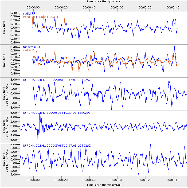
POHA Pohakuloa, Hawaii, USA - Earthquake Result Viewer
*The percent match for this event was below the threshold and hence no stack was calculated.
| Earthquake location: |
New Britain Region, P.N.G. |
| Earthquake latitude/longitude: |
-4.5/150.0 |
| Earthquake time(UTC): |
2000/05/08 (129) 10:28:25 GMT |
| Earthquake Depth: |
502 km |
| Earthquake Magnitude: |
5.7 MB, 6.1 MW, 6.1 MW |
| Earthquake Catalog/Contributor: |
WHDF/NEIC |
|
| Network: |
IU Global Seismograph Network (GSN - IRIS/USGS) |
| Station: |
POHA Pohakuloa, Hawaii, USA |
| Lat/Lon: |
19.76 N/155.53 W |
| Elevation: |
1967 m |
|
| Distance: |
58.7 deg |
| Az: |
63.79 deg |
| Baz: |
251.756 deg |
| Ray Param: |
$rayparam |
*The percent match for this event was below the threshold and hence was not used in the summary stack. |
|
| Radial Match: |
58.660427 % |
| Radial Bump: |
400 |
| Transverse Match: |
51.928795 % |
| Transverse Bump: |
400 |
| SOD ConfigId: |
590571 |
| Insert Time: |
2013-09-24 18:15:18.497 +0000 |
| GWidth: |
2.5 |
| Max Bumps: |
400 |
| Tol: |
0.001 |
|
Signal To Noise
| Channel | StoN | STA | LTA |
| IU:POHA:00:BHZ:20000508T10:37:03.125029Z | 2.131548 | 2.5269658E-6 | 1.1855074E-6 |
| IU:POHA:00:BH1:20000508T10:37:03.125029Z | 2.2634177 | 1.9869199E-6 | 8.7784053E-7 |
| IU:POHA:00:BH2:20000508T10:37:03.125029Z | 0.9166217 | 1.006683E-6 | 1.0982535E-6 |
| Arrivals |
| Ps | |
| PpPs | |
| PsPs/PpSs | |


