You are here: Home > Network List > TA - USArray Transportable Network (new EarthScope stations) Stations List
> Station MDND Maddock, ND, USA > Earthquake Result Viewer
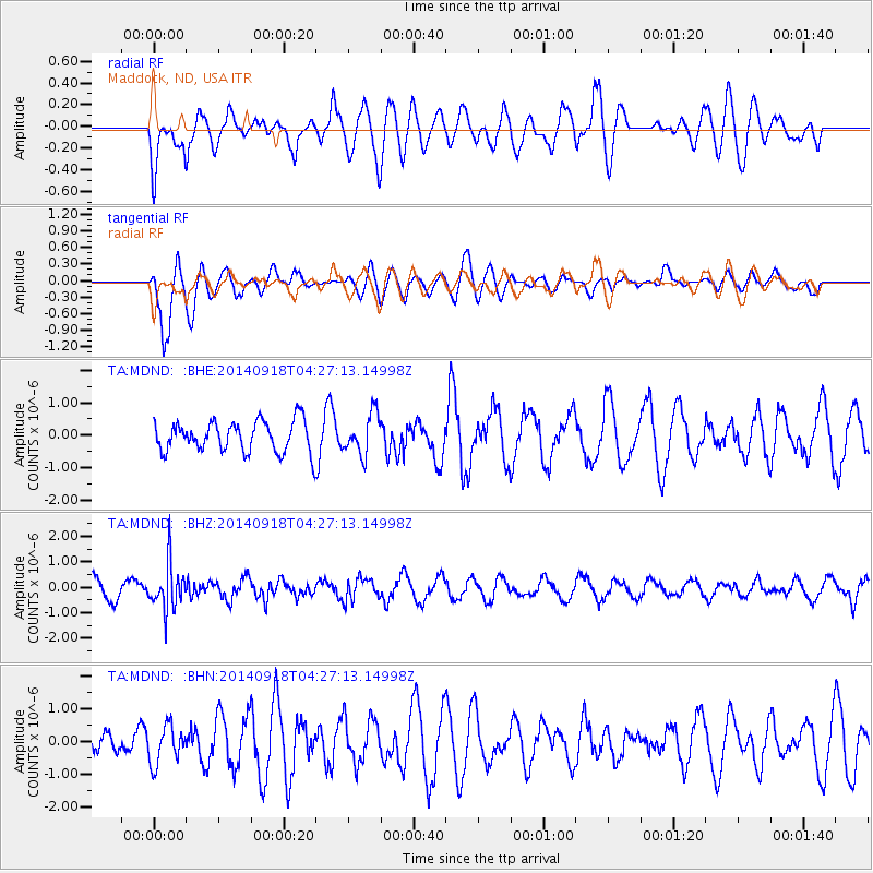
MDND Maddock, ND, USA - Earthquake Result Viewer
*The percent match for this event was below the threshold and hence no stack was calculated.
| Earthquake location: |
Northwest Of Kuril Islands |
| Earthquake latitude/longitude: |
50.6/150.2 |
| Earthquake time(UTC): |
2014/09/18 (261) 04:17:53 GMT |
| Earthquake Depth: |
502 km |
| Earthquake Magnitude: |
5.6 MW |
| Earthquake Catalog/Contributor: |
ISC/ISC |
|
| Network: |
TA USArray Transportable Network (new EarthScope stations) |
| Station: |
MDND Maddock, ND, USA |
| Lat/Lon: |
47.85 N/99.60 W |
| Elevation: |
479 m |
|
| Distance: |
65.1 deg |
| Az: |
44.169 deg |
| Baz: |
318.729 deg |
| Ray Param: |
$rayparam |
*The percent match for this event was below the threshold and hence was not used in the summary stack. |
|
| Radial Match: |
49.989746 % |
| Radial Bump: |
400 |
| Transverse Match: |
75.9105 % |
| Transverse Bump: |
400 |
| SOD ConfigId: |
3390531 |
| Insert Time: |
2019-04-14 02:49:47.775 +0000 |
| GWidth: |
2.5 |
| Max Bumps: |
400 |
| Tol: |
0.001 |
|
Signal To Noise
| Channel | StoN | STA | LTA |
| TA:MDND: :BHZ:20140918T04:27:13.14998Z | 3.0504627 | 8.9140974E-7 | 2.9222116E-7 |
| TA:MDND: :BHN:20140918T04:27:13.14998Z | 0.9296397 | 5.7815635E-7 | 6.219144E-7 |
| TA:MDND: :BHE:20140918T04:27:13.14998Z | 1.3011844 | 6.2034934E-7 | 4.767574E-7 |
| Arrivals |
| Ps | |
| PpPs | |
| PsPs/PpSs | |


