You are here: Home > Network List > TA - USArray Transportable Network (new EarthScope stations) Stations List
> Station N23A Red Feather Lakes, CO, USA > Earthquake Result Viewer
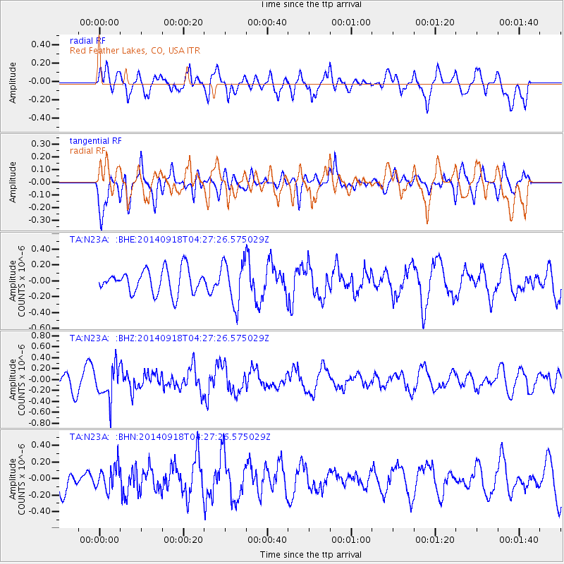
N23A Red Feather Lakes, CO, USA - Earthquake Result Viewer
*The percent match for this event was below the threshold and hence no stack was calculated.
| Earthquake location: |
Northwest Of Kuril Islands |
| Earthquake latitude/longitude: |
50.6/150.2 |
| Earthquake time(UTC): |
2014/09/18 (261) 04:17:53 GMT |
| Earthquake Depth: |
502 km |
| Earthquake Magnitude: |
5.6 MW |
| Earthquake Catalog/Contributor: |
ISC/ISC |
|
| Network: |
TA USArray Transportable Network (new EarthScope stations) |
| Station: |
N23A Red Feather Lakes, CO, USA |
| Lat/Lon: |
40.89 N/105.94 W |
| Elevation: |
2458 m |
|
| Distance: |
67.3 deg |
| Az: |
52.931 deg |
| Baz: |
317.844 deg |
| Ray Param: |
$rayparam |
*The percent match for this event was below the threshold and hence was not used in the summary stack. |
|
| Radial Match: |
63.092594 % |
| Radial Bump: |
400 |
| Transverse Match: |
61.462944 % |
| Transverse Bump: |
400 |
| SOD ConfigId: |
3390531 |
| Insert Time: |
2019-04-14 02:49:48.118 +0000 |
| GWidth: |
2.5 |
| Max Bumps: |
400 |
| Tol: |
0.001 |
|
Signal To Noise
| Channel | StoN | STA | LTA |
| TA:N23A: :BHZ:20140918T04:27:26.575029Z | 2.4051526 | 3.002132E-7 | 1.2482086E-7 |
| TA:N23A: :BHN:20140918T04:27:26.575029Z | 0.8929718 | 1.48586E-7 | 1.6639495E-7 |
| TA:N23A: :BHE:20140918T04:27:26.575029Z | 1.8483143 | 2.779217E-7 | 1.5036497E-7 |
| Arrivals |
| Ps | |
| PpPs | |
| PsPs/PpSs | |


