You are here: Home > Network List > IU - Global Seismograph Network (GSN - IRIS/USGS) Stations List
> Station POHA Pohakuloa, Hawaii, USA > Earthquake Result Viewer
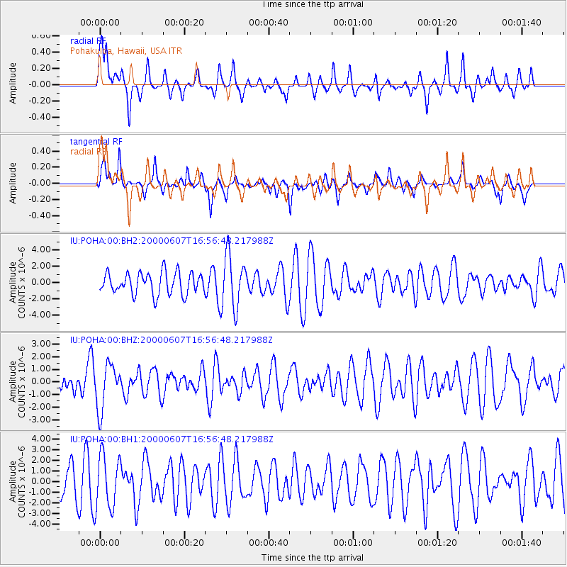
POHA Pohakuloa, Hawaii, USA - Earthquake Result Viewer
*The percent match for this event was below the threshold and hence no stack was calculated.
| Earthquake location: |
Talaud Islands, Indonesia |
| Earthquake latitude/longitude: |
4.9/126.8 |
| Earthquake time(UTC): |
2000/06/07 (159) 16:45:37 GMT |
| Earthquake Depth: |
86 km |
| Earthquake Magnitude: |
5.5 MW |
| Earthquake Catalog/Contributor: |
NEIC PDE/NEIC PDE-M |
|
| Network: |
IU Global Seismograph Network (GSN - IRIS/USGS) |
| Station: |
POHA Pohakuloa, Hawaii, USA |
| Lat/Lon: |
19.76 N/155.53 W |
| Elevation: |
1967 m |
|
| Distance: |
76.7 deg |
| Az: |
70.958 deg |
| Baz: |
270.529 deg |
| Ray Param: |
$rayparam |
*The percent match for this event was below the threshold and hence was not used in the summary stack. |
|
| Radial Match: |
47.941696 % |
| Radial Bump: |
353 |
| Transverse Match: |
32.434902 % |
| Transverse Bump: |
245 |
| SOD ConfigId: |
590571 |
| Insert Time: |
2013-09-24 18:22:31.695 +0000 |
| GWidth: |
2.5 |
| Max Bumps: |
400 |
| Tol: |
0.001 |
|
Signal To Noise
| Channel | StoN | STA | LTA |
| IU:POHA:00:BHZ:20000607T16:56:48.217988Z | 1.869053 | 1.8438384E-6 | 9.865093E-7 |
| IU:POHA:00:BH1:20000607T16:56:48.217988Z | 1.3060209 | 2.442619E-6 | 1.8702756E-6 |
| IU:POHA:00:BH2:20000607T16:56:48.217988Z | 2.4275513 | 3.196503E-6 | 1.3167602E-6 |
| Arrivals |
| Ps | |
| PpPs | |
| PsPs/PpSs | |


