You are here: Home > Network List > TA - USArray Transportable Network (new EarthScope stations) Stations List
> Station P59A Jarrettsville, MD, USA > Earthquake Result Viewer
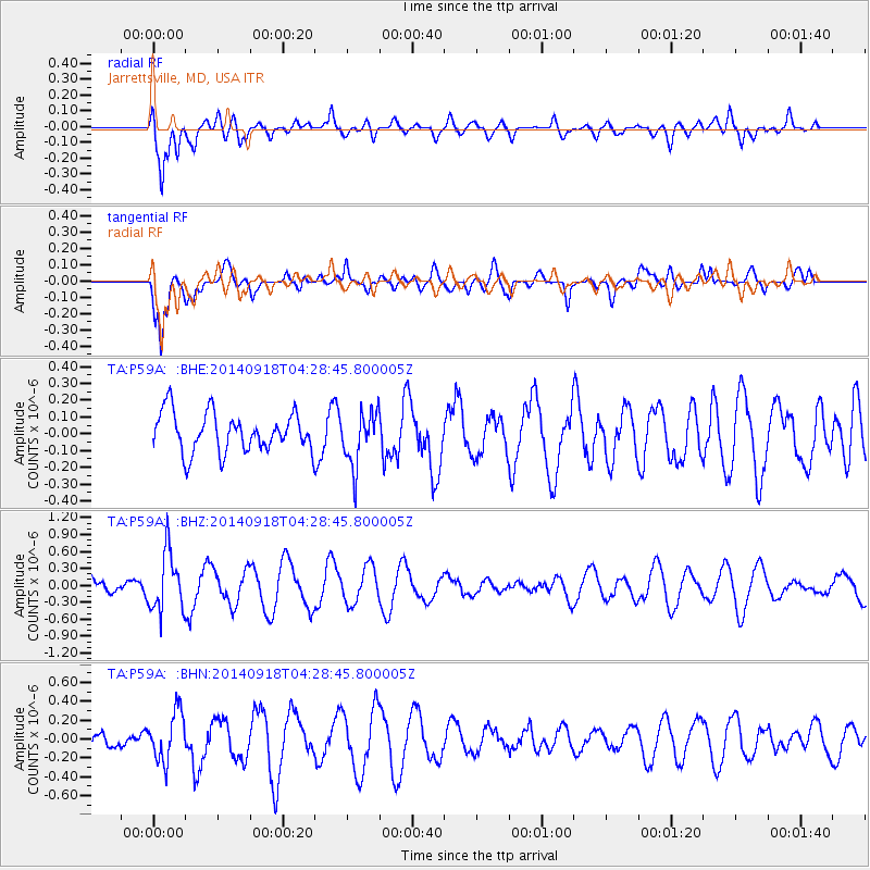
P59A Jarrettsville, MD, USA - Earthquake Result Viewer
*The percent match for this event was below the threshold and hence no stack was calculated.
| Earthquake location: |
Northwest Of Kuril Islands |
| Earthquake latitude/longitude: |
50.6/150.2 |
| Earthquake time(UTC): |
2014/09/18 (261) 04:17:53 GMT |
| Earthquake Depth: |
502 km |
| Earthquake Magnitude: |
5.6 MW |
| Earthquake Catalog/Contributor: |
ISC/ISC |
|
| Network: |
TA USArray Transportable Network (new EarthScope stations) |
| Station: |
P59A Jarrettsville, MD, USA |
| Lat/Lon: |
39.61 N/76.43 W |
| Elevation: |
157 m |
|
| Distance: |
81.3 deg |
| Az: |
34.599 deg |
| Baz: |
332.049 deg |
| Ray Param: |
$rayparam |
*The percent match for this event was below the threshold and hence was not used in the summary stack. |
|
| Radial Match: |
77.554115 % |
| Radial Bump: |
400 |
| Transverse Match: |
82.32893 % |
| Transverse Bump: |
400 |
| SOD ConfigId: |
3390531 |
| Insert Time: |
2019-04-14 02:49:58.523 +0000 |
| GWidth: |
2.5 |
| Max Bumps: |
400 |
| Tol: |
0.001 |
|
Signal To Noise
| Channel | StoN | STA | LTA |
| TA:P59A: :BHZ:20140918T04:28:45.800005Z | 2.812486 | 5.231123E-7 | 1.8599643E-7 |
| TA:P59A: :BHN:20140918T04:28:45.800005Z | 1.7840134 | 2.585322E-7 | 1.4491606E-7 |
| TA:P59A: :BHE:20140918T04:28:45.800005Z | 1.3831253 | 1.6072298E-7 | 1.16202756E-7 |
| Arrivals |
| Ps | |
| PpPs | |
| PsPs/PpSs | |


