You are here: Home > Network List > II - Global Seismograph Network (GSN - IRIS/IDA) Stations List
> Station MBAR Mbarara, Uganda > Earthquake Result Viewer
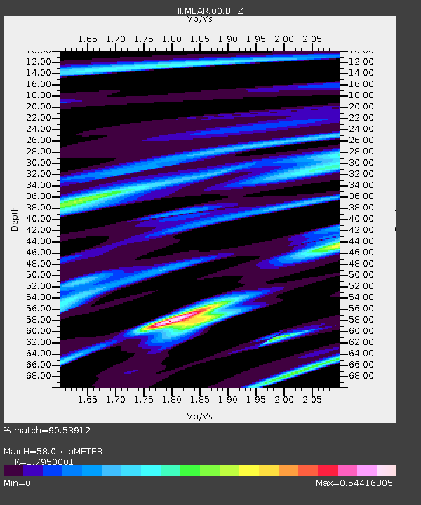
MBAR Mbarara, Uganda - Earthquake Result Viewer
| Earthquake location: |
Taiwan |
| Earthquake latitude/longitude: |
23.8/121.2 |
| Earthquake time(UTC): |
2000/06/10 (162) 18:23:29 GMT |
| Earthquake Depth: |
33 km |
| Earthquake Magnitude: |
6.2 MB, 6.2 MS, 6.4 MW, 6.3 MW |
| Earthquake Catalog/Contributor: |
WHDF/NEIC |
|
| Network: |
II Global Seismograph Network (GSN - IRIS/IDA) |
| Station: |
MBAR Mbarara, Uganda |
| Lat/Lon: |
0.60 S/30.74 E |
| Elevation: |
1390 m |
|
| Distance: |
90.7 deg |
| Az: |
269.648 deg |
| Baz: |
66.304 deg |
| Ray Param: |
0.04165171 |
| Estimated Moho Depth: |
58.0 km |
| Estimated Crust Vp/Vs: |
1.80 |
| Assumed Crust Vp: |
6.419 km/s |
| Estimated Crust Vs: |
3.576 km/s |
| Estimated Crust Poisson's Ratio: |
0.27 |
|
| Radial Match: |
90.53912 % |
| Radial Bump: |
329 |
| Transverse Match: |
84.68636 % |
| Transverse Bump: |
400 |
| SOD ConfigId: |
590571 |
| Insert Time: |
2013-09-24 18:25:28.021 +0000 |
| GWidth: |
2.5 |
| Max Bumps: |
400 |
| Tol: |
0.001 |
|

Signal To Noise
| Channel | StoN | STA | LTA |
| II:MBAR:00:BHZ:20000610T18:35:57.369988Z | 3.517213 | 1.8111186E-7 | 5.1493E-8 |
| II:MBAR:00:BH1:20000610T18:35:57.369988Z | 1.2789516 | 4.8098165E-8 | 3.7607496E-8 |
| II:MBAR:00:BH2:20000610T18:35:57.369988Z | 2.5949798 | 6.599484E-8 | 2.5431737E-8 |
| Arrivals |
| Ps | 7.3 SECOND |
| PpPs | 25 SECOND |
| PsPs/PpSs | 32 SECOND |


