You are here: Home > Network List > IU - Global Seismograph Network (GSN - IRIS/USGS) Stations List
> Station POHA Pohakuloa, Hawaii, USA > Earthquake Result Viewer
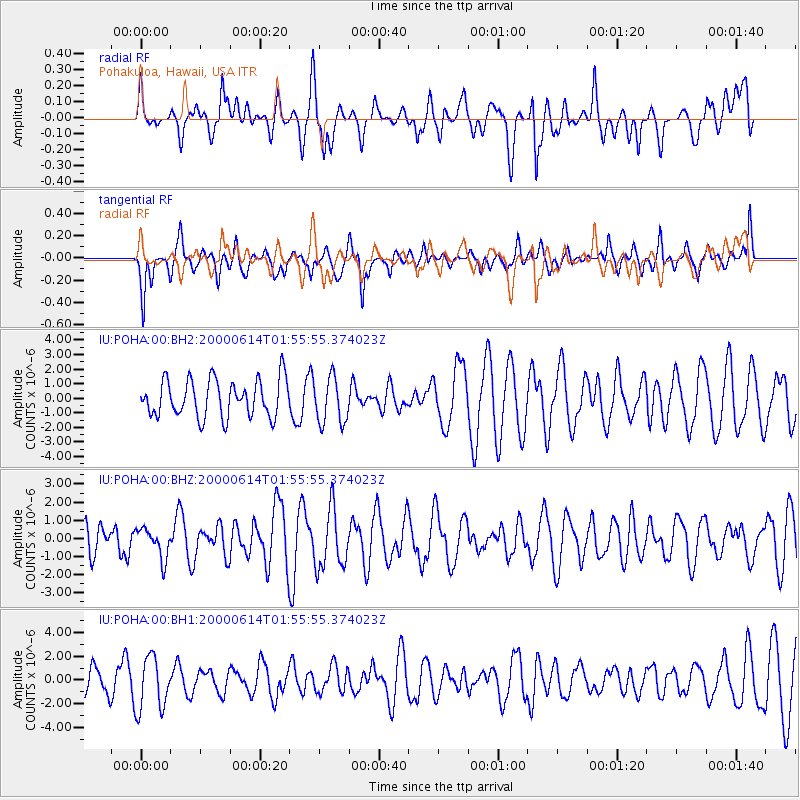
POHA Pohakuloa, Hawaii, USA - Earthquake Result Viewer
*The percent match for this event was below the threshold and hence no stack was calculated.
| Earthquake location: |
Luzon, Philippines |
| Earthquake latitude/longitude: |
17.3/120.2 |
| Earthquake time(UTC): |
2000/06/14 (166) 01:44:28 GMT |
| Earthquake Depth: |
63 km |
| Earthquake Magnitude: |
5.5 MB, 5.7 MW |
| Earthquake Catalog/Contributor: |
NEIC PDE/NEIC PDE-M |
|
| Network: |
IU Global Seismograph Network (GSN - IRIS/USGS) |
| Station: |
POHA Pohakuloa, Hawaii, USA |
| Lat/Lon: |
19.76 N/155.53 W |
| Elevation: |
1967 m |
|
| Distance: |
79.1 deg |
| Az: |
72.629 deg |
| Baz: |
284.542 deg |
| Ray Param: |
$rayparam |
*The percent match for this event was below the threshold and hence was not used in the summary stack. |
|
| Radial Match: |
52.97843 % |
| Radial Bump: |
400 |
| Transverse Match: |
68.25711 % |
| Transverse Bump: |
364 |
| SOD ConfigId: |
590571 |
| Insert Time: |
2013-09-24 18:26:04.033 +0000 |
| GWidth: |
2.5 |
| Max Bumps: |
400 |
| Tol: |
0.001 |
|
Signal To Noise
| Channel | StoN | STA | LTA |
| IU:POHA:00:BHZ:20000614T01:55:55.374023Z | 0.94158673 | 8.2379023E-7 | 8.748957E-7 |
| IU:POHA:00:BH1:20000614T01:55:55.374023Z | 1.9574717 | 2.2436693E-6 | 1.1462078E-6 |
| IU:POHA:00:BH2:20000614T01:55:55.374023Z | 1.2439759 | 1.5903034E-6 | 1.2784038E-6 |
| Arrivals |
| Ps | |
| PpPs | |
| PsPs/PpSs | |


