You are here: Home > Network List > TA - USArray Transportable Network (new EarthScope stations) Stations List
> Station U57A Blanch, NC, USA > Earthquake Result Viewer
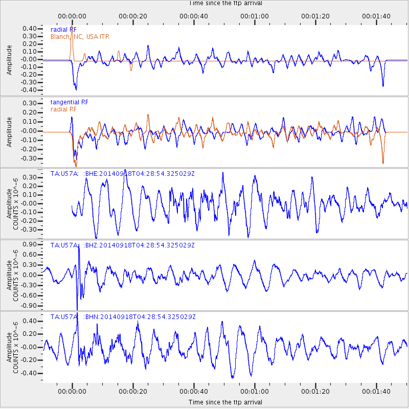
U57A Blanch, NC, USA - Earthquake Result Viewer
*The percent match for this event was below the threshold and hence no stack was calculated.
| Earthquake location: |
Northwest Of Kuril Islands |
| Earthquake latitude/longitude: |
50.6/150.2 |
| Earthquake time(UTC): |
2014/09/18 (261) 04:17:53 GMT |
| Earthquake Depth: |
502 km |
| Earthquake Magnitude: |
5.6 MW |
| Earthquake Catalog/Contributor: |
ISC/ISC |
|
| Network: |
TA USArray Transportable Network (new EarthScope stations) |
| Station: |
U57A Blanch, NC, USA |
| Lat/Lon: |
36.43 N/79.34 W |
| Elevation: |
178 m |
|
| Distance: |
83.0 deg |
| Az: |
38.164 deg |
| Baz: |
330.753 deg |
| Ray Param: |
$rayparam |
*The percent match for this event was below the threshold and hence was not used in the summary stack. |
|
| Radial Match: |
62.446575 % |
| Radial Bump: |
400 |
| Transverse Match: |
74.551155 % |
| Transverse Bump: |
400 |
| SOD ConfigId: |
3390531 |
| Insert Time: |
2019-04-14 02:50:20.570 +0000 |
| GWidth: |
2.5 |
| Max Bumps: |
400 |
| Tol: |
0.001 |
|
Signal To Noise
| Channel | StoN | STA | LTA |
| TA:U57A: :BHZ:20140918T04:28:54.325029Z | 2.0541687 | 3.940969E-7 | 1.9185225E-7 |
| TA:U57A: :BHN:20140918T04:28:54.325029Z | 2.0244522 | 1.981109E-7 | 9.7859015E-8 |
| TA:U57A: :BHE:20140918T04:28:54.325029Z | 0.55001354 | 1.07238996E-7 | 1.949752E-7 |
| Arrivals |
| Ps | |
| PpPs | |
| PsPs/PpSs | |


