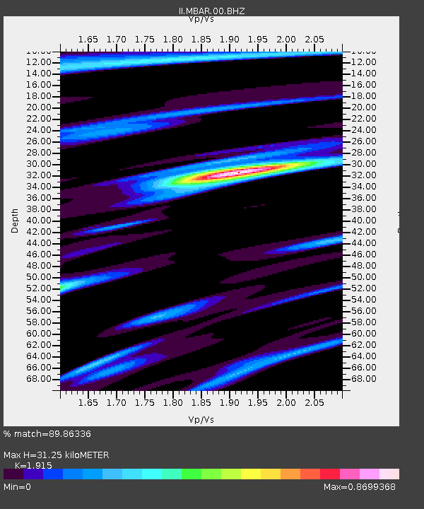
MBAR Mbarara, Uganda - Earthquake Result Viewer

Earthquake location: Southern Sumatra, Indonesia
Earthquake latitude/longitude: -5.4/102.7
Earthquake time(UTC): 2000/07/08 (190) 04:52:55 GMT
Earthquake Depth: 33 km
Earthquake Magnitude: 5.7 MB, 5.7 MS, 5.9 MW, 5.8 MW
Earthquake Catalog/Contributor: WHDF/NEIC
Network: II Global Seismograph Network (GSN - IRIS/IDA)
Station: MBAR Mbarara, Uganda
Lat/Lon: 0.60 S/30.74 E
Elevation: 1390 m
Distance: 72.0 deg
Az: 271.121 deg
Baz: 95.455 deg
Ray Param: 0.053912677
Estimated Moho Depth: 31.25 km
Estimated Crust Vp/Vs: 1.91
Assumed Crust Vp: 6.419 km/s
Estimated Crust Vs: 3.352 km/s
Estimated Crust Poisson's Ratio: 0.31
Radial Match: 89.86336 %
Radial Bump: 384
Transverse Match: 73.57651 %
Transverse Bump: 400
SOD ConfigId: 590571
Insert Time: 2013-09-24 18:34:37.677 +0000
GWidth: 2.5
Max Bumps: 400
Tol: 0.001

Signal To Noise

ChannelStoNSTALTA
II:MBAR:00:BHZ:20000708T05:03:44.836025Z10.4899545.3414453E-75.0919624E-8
II:MBAR:00:BH1:20000708T05:03:44.836025Z1.48803566.996807E-84.7020432E-8
II:MBAR:00:BH2:20000708T05:03:44.836025Z4.6570491.9300799E-74.1444263E-8
Arrivals
Ps4.6 SECOND
PpPs14 SECOND
PsPs/PpSs18 SECOND