You are here: Home > Network List > US - United States National Seismic Network Stations List
> Station ERPA Erie, Pennsylvania, USA > Earthquake Result Viewer
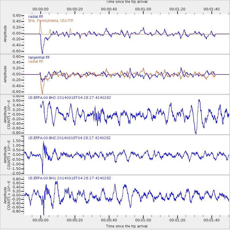
ERPA Erie, Pennsylvania, USA - Earthquake Result Viewer
*The percent match for this event was below the threshold and hence no stack was calculated.
| Earthquake location: |
Northwest Of Kuril Islands |
| Earthquake latitude/longitude: |
50.6/150.2 |
| Earthquake time(UTC): |
2014/09/18 (261) 04:17:53 GMT |
| Earthquake Depth: |
502 km |
| Earthquake Magnitude: |
5.6 MW |
| Earthquake Catalog/Contributor: |
ISC/ISC |
|
| Network: |
US United States National Seismic Network |
| Station: |
ERPA Erie, Pennsylvania, USA |
| Lat/Lon: |
42.12 N/79.99 W |
| Elevation: |
306 m |
|
| Distance: |
77.8 deg |
| Az: |
35.763 deg |
| Baz: |
329.941 deg |
| Ray Param: |
$rayparam |
*The percent match for this event was below the threshold and hence was not used in the summary stack. |
|
| Radial Match: |
63.883575 % |
| Radial Bump: |
400 |
| Transverse Match: |
64.68271 % |
| Transverse Bump: |
400 |
| SOD ConfigId: |
3390531 |
| Insert Time: |
2019-04-14 02:51:09.878 +0000 |
| GWidth: |
2.5 |
| Max Bumps: |
400 |
| Tol: |
0.001 |
|
Signal To Noise
| Channel | StoN | STA | LTA |
| US:ERPA:00:BHZ:20140918T04:28:27.424028Z | 2.2576194 | 6.463683E-7 | 2.8630524E-7 |
| US:ERPA:00:BH1:20140918T04:28:27.424028Z | 2.0241256 | 3.0288913E-7 | 1.496395E-7 |
| US:ERPA:00:BH2:20140918T04:28:27.424028Z | 0.7277909 | 1.853866E-7 | 2.5472508E-7 |
| Arrivals |
| Ps | |
| PpPs | |
| PsPs/PpSs | |


