You are here: Home > Network List > IU - Global Seismograph Network (GSN - IRIS/USGS) Stations List
> Station RSSD Black Hills, South Dakota, USA > Earthquake Result Viewer
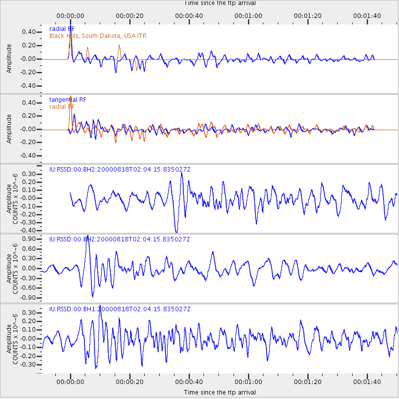
RSSD Black Hills, South Dakota, USA - Earthquake Result Viewer
*The percent match for this event was below the threshold and hence no stack was calculated.
| Earthquake location: |
Near S. Coast Of Honshu, Japan |
| Earthquake latitude/longitude: |
34.1/139.2 |
| Earthquake time(UTC): |
2000/08/18 (231) 01:52:20 GMT |
| Earthquake Depth: |
10 km |
| Earthquake Magnitude: |
5.6 MB, 5.5 MS, 5.8 MW, 5.7 MW |
| Earthquake Catalog/Contributor: |
WHDF/NEIC |
|
| Network: |
IU Global Seismograph Network (GSN - IRIS/USGS) |
| Station: |
RSSD Black Hills, South Dakota, USA |
| Lat/Lon: |
44.12 N/104.04 W |
| Elevation: |
2060 m |
|
| Distance: |
83.2 deg |
| Az: |
40.352 deg |
| Baz: |
311.775 deg |
| Ray Param: |
$rayparam |
*The percent match for this event was below the threshold and hence was not used in the summary stack. |
|
| Radial Match: |
76.28207 % |
| Radial Bump: |
326 |
| Transverse Match: |
66.84437 % |
| Transverse Bump: |
400 |
| SOD ConfigId: |
590571 |
| Insert Time: |
2013-09-24 18:53:15.596 +0000 |
| GWidth: |
2.5 |
| Max Bumps: |
400 |
| Tol: |
0.001 |
|
Signal To Noise
| Channel | StoN | STA | LTA |
| IU:RSSD:00:BHZ:20000818T02:04:15.835027Z | 2.0056412 | 1.9553114E-7 | 9.749059E-8 |
| IU:RSSD:00:BH1:20000818T02:04:15.835027Z | 1.2182846 | 9.010828E-8 | 7.396324E-8 |
| IU:RSSD:00:BH2:20000818T02:04:15.835027Z | 1.2834331 | 9.412393E-8 | 7.3337624E-8 |
| Arrivals |
| Ps | |
| PpPs | |
| PsPs/PpSs | |


