You are here: Home > Network List > IU - Global Seismograph Network (GSN - IRIS/USGS) Stations List
> Station SNZO South Karori, New Zealand > Earthquake Result Viewer
SNZO South Karori, New Zealand - Earthquake Result Viewer
| Earthquake location: |
Banda Sea |
| Earthquake latitude/longitude: |
-4.1/127.4 |
| Earthquake time(UTC): |
2000/08/28 (241) 15:05:47 GMT |
| Earthquake Depth: |
16 km |
| Earthquake Magnitude: |
6.5 MB, 6.8 MS, 6.8 MW, 6.7 ME |
| Earthquake Catalog/Contributor: |
WHDF/NEIC |
|
| Network: |
IU Global Seismograph Network (GSN - IRIS/USGS) |
| Station: |
SNZO South Karori, New Zealand |
| Lat/Lon: |
41.31 S/174.70 E |
| Elevation: |
62 m |
|
| Distance: |
56.2 deg |
| Az: |
138.213 deg |
| Baz: |
298.078 deg |
| Ray Param: |
0.06428322 |
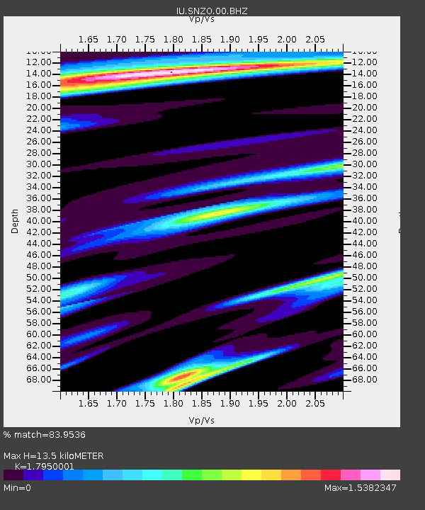
| Estimated Moho Depth: |
13.5 km |
| Estimated Crust Vp/Vs: |
1.80 |
| Assumed Crust Vp: |
6.461 km/s |
| Estimated Crust Vs: |
3.6 km/s |
| Estimated Crust Poisson's Ratio: |
0.27 |
|
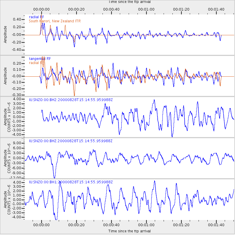
| Radial Match: |
83.9536 % |
| Radial Bump: |
400 |
| Transverse Match: |
72.55219 % |
| Transverse Bump: |
400 |
| SOD ConfigId: |
590571 |
| Insert Time: |
2013-09-24 18:56:42.770 +0000 |
| GWidth: |
2.5 |
| Max Bumps: |
400 |
| Tol: |
0.001 |
|
Signal To Noise
| Channel | StoN | STA | LTA |
| IU:SNZO:00:BHZ:20000828T15:14:55.959988Z | 2.6533358 | 1.8271274E-6 | 6.886152E-7 |
| IU:SNZO:00:BH1:20000828T15:14:55.959988Z | 1.8294001 | 1.3774569E-6 | 7.529555E-7 |
| IU:SNZO:00:BH2:20000828T15:14:55.959988Z | 1.6023762 | 1.0194032E-6 | 6.3618216E-7 |
| Arrivals |
| Ps | 1.7 SECOND |
| PpPs | 5.5 SECOND |
| PsPs/PpSs | 7.3 SECOND |


