You are here: Home > Network List > IU - Global Seismograph Network (GSN - IRIS/USGS) Stations List
> Station RSSD Black Hills, South Dakota, USA > Earthquake Result Viewer
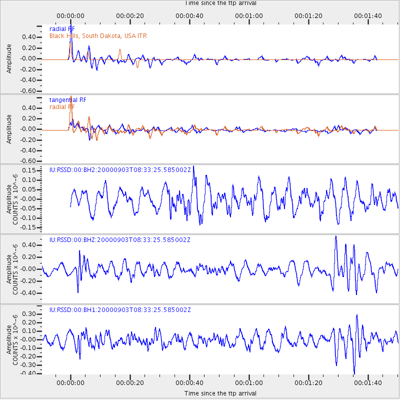
RSSD Black Hills, South Dakota, USA - Earthquake Result Viewer
*The percent match for this event was below the threshold and hence no stack was calculated.
| Earthquake location: |
Fiji Islands Region |
| Earthquake latitude/longitude: |
-20.5/-177.8 |
| Earthquake time(UTC): |
2000/09/03 (247) 08:21:23 GMT |
| Earthquake Depth: |
364 km |
| Earthquake Magnitude: |
5.8 MW |
| Earthquake Catalog/Contributor: |
NEIC PDE/NEIC PDE-M |
|
| Network: |
IU Global Seismograph Network (GSN - IRIS/USGS) |
| Station: |
RSSD Black Hills, South Dakota, USA |
| Lat/Lon: |
44.12 N/104.04 W |
| Elevation: |
2060 m |
|
| Distance: |
93.1 deg |
| Az: |
43.833 deg |
| Baz: |
244.312 deg |
| Ray Param: |
$rayparam |
*The percent match for this event was below the threshold and hence was not used in the summary stack. |
|
| Radial Match: |
63.30301 % |
| Radial Bump: |
294 |
| Transverse Match: |
44.944805 % |
| Transverse Bump: |
400 |
| SOD ConfigId: |
590571 |
| Insert Time: |
2013-09-24 18:59:18.880 +0000 |
| GWidth: |
2.5 |
| Max Bumps: |
400 |
| Tol: |
0.001 |
|
Signal To Noise
| Channel | StoN | STA | LTA |
| IU:RSSD:00:BHZ:20000903T08:33:25.585002Z | 2.068965 | 1.409494E-7 | 6.812556E-8 |
| IU:RSSD:00:BH1:20000903T08:33:25.585002Z | 1.9844497 | 9.691599E-8 | 4.8837713E-8 |
| IU:RSSD:00:BH2:20000903T08:33:25.585002Z | 1.1864774 | 5.7597763E-8 | 4.8545182E-8 |
| Arrivals |
| Ps | |
| PpPs | |
| PsPs/PpSs | |


