You are here: Home > Network List > II - Global Seismograph Network (GSN - IRIS/IDA) Stations List
> Station MBAR Mbarara, Uganda > Earthquake Result Viewer
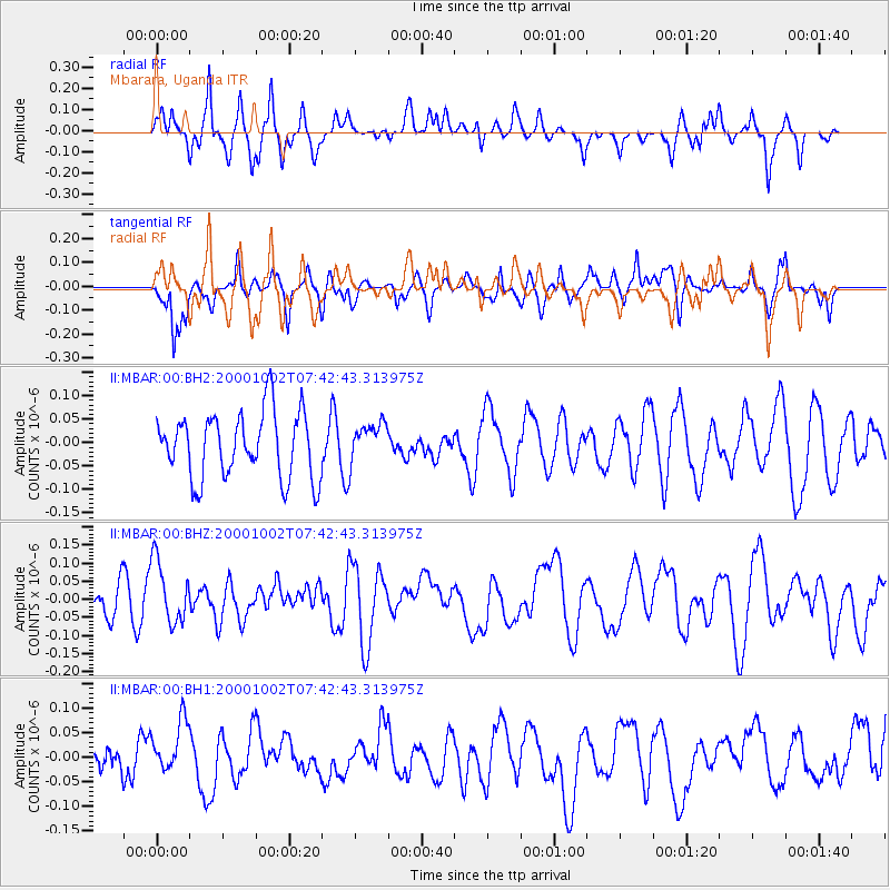
MBAR Mbarara, Uganda - Earthquake Result Viewer
*The percent match for this event was below the threshold and hence no stack was calculated.
| Earthquake location: |
Ryukyu Islands, Japan |
| Earthquake latitude/longitude: |
29.4/129.4 |
| Earthquake time(UTC): |
2000/10/02 (276) 07:29:42 GMT |
| Earthquake Depth: |
33 km |
| Earthquake Magnitude: |
5.4 MB, 5.1 MS, 5.6 MW, 5.4 MW |
| Earthquake Catalog/Contributor: |
WHDF/NEIC |
|
| Network: |
II Global Seismograph Network (GSN - IRIS/IDA) |
| Station: |
MBAR Mbarara, Uganda |
| Lat/Lon: |
0.60 S/30.74 E |
| Elevation: |
1390 m |
|
| Distance: |
97.8 deg |
| Az: |
273.73 deg |
| Baz: |
60.511 deg |
| Ray Param: |
$rayparam |
*The percent match for this event was below the threshold and hence was not used in the summary stack. |
|
| Radial Match: |
70.24795 % |
| Radial Bump: |
400 |
| Transverse Match: |
55.11564 % |
| Transverse Bump: |
400 |
| SOD ConfigId: |
590571 |
| Insert Time: |
2013-09-24 19:08:27.467 +0000 |
| GWidth: |
2.5 |
| Max Bumps: |
400 |
| Tol: |
0.001 |
|
Signal To Noise
| Channel | StoN | STA | LTA |
| II:MBAR:00:BHZ:20001002T07:42:43.313975Z | 1.2509499 | 8.502732E-8 | 6.79702E-8 |
| II:MBAR:00:BH1:20001002T07:42:43.313975Z | 0.85912734 | 6.193366E-8 | 7.208904E-8 |
| II:MBAR:00:BH2:20001002T07:42:43.313975Z | 0.61867756 | 4.3238376E-8 | 6.988839E-8 |
| Arrivals |
| Ps | |
| PpPs | |
| PsPs/PpSs | |


