You are here: Home > Network List > IU - Global Seismograph Network (GSN - IRIS/USGS) Stations List
> Station JOHN Johnston Island, USA > Earthquake Result Viewer
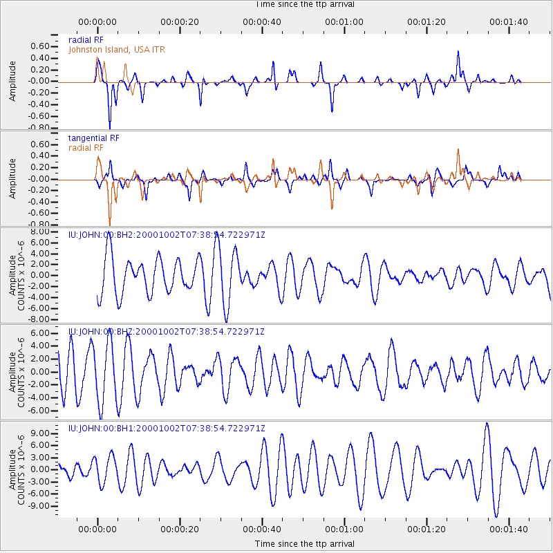
JOHN Johnston Island, USA - Earthquake Result Viewer
*The percent match for this event was below the threshold and hence no stack was calculated.
| Earthquake location: |
Ryukyu Islands, Japan |
| Earthquake latitude/longitude: |
29.4/129.4 |
| Earthquake time(UTC): |
2000/10/02 (276) 07:29:42 GMT |
| Earthquake Depth: |
33 km |
| Earthquake Magnitude: |
5.4 MB, 5.1 MS, 5.6 MW, 5.4 MW |
| Earthquake Catalog/Contributor: |
WHDF/NEIC |
|
| Network: |
IU Global Seismograph Network (GSN - IRIS/USGS) |
| Station: |
JOHN Johnston Island, USA |
| Lat/Lon: |
16.73 N/169.53 W |
| Elevation: |
2.0 m |
|
| Distance: |
57.0 deg |
| Az: |
88.43 deg |
| Baz: |
294.498 deg |
| Ray Param: |
$rayparam |
*The percent match for this event was below the threshold and hence was not used in the summary stack. |
|
| Radial Match: |
72.15311 % |
| Radial Bump: |
241 |
| Transverse Match: |
47.999844 % |
| Transverse Bump: |
351 |
| SOD ConfigId: |
590571 |
| Insert Time: |
2013-09-24 19:08:33.732 +0000 |
| GWidth: |
2.5 |
| Max Bumps: |
400 |
| Tol: |
0.001 |
|
Signal To Noise
| Channel | StoN | STA | LTA |
| IU:JOHN:00:BHZ:20001002T07:38:54.722971Z | 1.921452 | 4.6843775E-6 | 2.4379362E-6 |
| IU:JOHN:00:BH1:20001002T07:38:54.722971Z | 1.2058631 | 3.317015E-6 | 2.750739E-6 |
| IU:JOHN:00:BH2:20001002T07:38:54.722971Z | 1.6218492 | 5.231594E-6 | 3.2256971E-6 |
| Arrivals |
| Ps | |
| PpPs | |
| PsPs/PpSs | |


