You are here: Home > Network List > II - Global Seismograph Network (GSN - IRIS/IDA) Stations List
> Station MBAR Mbarara, Uganda > Earthquake Result Viewer
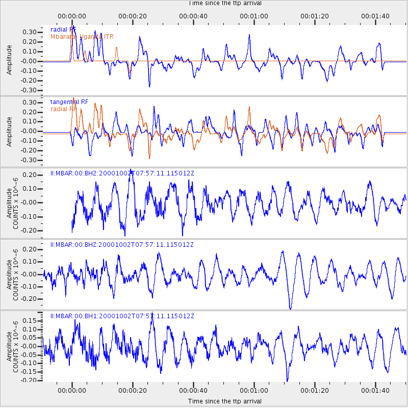
MBAR Mbarara, Uganda - Earthquake Result Viewer
*The percent match for this event was below the threshold and hence no stack was calculated.
| Earthquake location: |
Ryukyu Islands, Japan |
| Earthquake latitude/longitude: |
29.5/129.4 |
| Earthquake time(UTC): |
2000/10/02 (276) 07:44:10 GMT |
| Earthquake Depth: |
33 km |
| Earthquake Magnitude: |
5.6 MB, 5.2 MS, 5.6 MW, 5.5 MW |
| Earthquake Catalog/Contributor: |
WHDF/NEIC |
|
| Network: |
II Global Seismograph Network (GSN - IRIS/IDA) |
| Station: |
MBAR Mbarara, Uganda |
| Lat/Lon: |
0.60 S/30.74 E |
| Elevation: |
1390 m |
|
| Distance: |
97.8 deg |
| Az: |
273.744 deg |
| Baz: |
60.433 deg |
| Ray Param: |
$rayparam |
*The percent match for this event was below the threshold and hence was not used in the summary stack. |
|
| Radial Match: |
39.065853 % |
| Radial Bump: |
400 |
| Transverse Match: |
63.558228 % |
| Transverse Bump: |
400 |
| SOD ConfigId: |
590571 |
| Insert Time: |
2013-09-24 19:08:46.611 +0000 |
| GWidth: |
2.5 |
| Max Bumps: |
400 |
| Tol: |
0.001 |
|
Signal To Noise
| Channel | StoN | STA | LTA |
| II:MBAR:00:BHZ:20001002T07:57:11.115012Z | 0.86678654 | 5.2479706E-8 | 6.0545126E-8 |
| II:MBAR:00:BH1:20001002T07:57:11.115012Z | 1.4722373 | 8.565994E-8 | 5.8183513E-8 |
| II:MBAR:00:BH2:20001002T07:57:11.115012Z | 0.95639837 | 1.02351414E-7 | 1.07017556E-7 |
| Arrivals |
| Ps | |
| PpPs | |
| PsPs/PpSs | |


