You are here: Home > Network List > XL12 - Hangay Dome, Mongolia Stations List
> Station HV21 HV21 > Earthquake Result Viewer
HV21 HV21 - Earthquake Result Viewer
| Earthquake location: |
Northwest Of Kuril Islands |
| Earthquake latitude/longitude: |
50.6/150.2 |
| Earthquake time(UTC): |
2014/09/18 (261) 04:17:53 GMT |
| Earthquake Depth: |
502 km |
| Earthquake Magnitude: |
5.6 MW |
| Earthquake Catalog/Contributor: |
ISC/ISC |
|
| Network: |
XL Hangay Dome, Mongolia |
| Station: |
HV21 HV21 |
| Lat/Lon: |
51.43 N/100.78 E |
| Elevation: |
1677 m |
|
| Distance: |
30.6 deg |
| Az: |
291.094 deg |
| Baz: |
71.856 deg |
| Ray Param: |
0.077379815 |
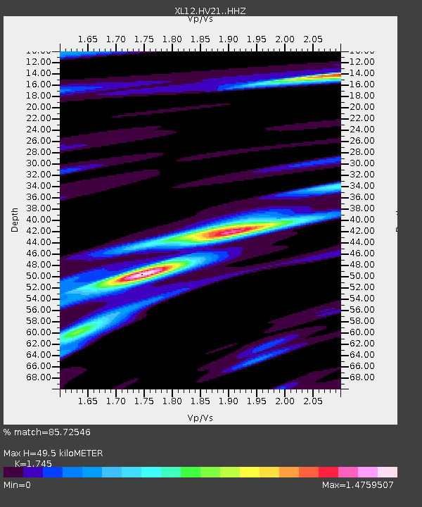
| Estimated Moho Depth: |
49.5 km |
| Estimated Crust Vp/Vs: |
1.75 |
| Assumed Crust Vp: |
6.419 km/s |
| Estimated Crust Vs: |
3.679 km/s |
| Estimated Crust Poisson's Ratio: |
0.26 |
|
| Radial Match: |
85.72546 % |
| Radial Bump: |
335 |
| Transverse Match: |
68.71756 % |
| Transverse Bump: |
400 |
| SOD ConfigId: |
3390531 |
| Insert Time: |
2019-04-14 02:52:53.813 +0000 |
| GWidth: |
2.5 |
| Max Bumps: |
400 |
| Tol: |
0.001 |
|

Signal To Noise
| Channel | StoN | STA | LTA |
| XL:HV21: :HHZ:20140918T04:22:55.520006Z | 23.9532 | 7.049691E-7 | 2.9431105E-8 |
| XL:HV21: :HHN:20140918T04:22:55.520006Z | 9.386819 | 2.1888327E-7 | 2.3318153E-8 |
| XL:HV21: :HHE:20140918T04:22:55.520006Z | 11.100279 | 3.8266865E-7 | 3.4473786E-8 |
| Arrivals |
| Ps | 6.2 SECOND |
| PpPs | 20 SECOND |
| PsPs/PpSs | 26 SECOND |


