You are here: Home > Network List > IU - Global Seismograph Network (GSN - IRIS/USGS) Stations List
> Station JOHN Johnston Island, USA > Earthquake Result Viewer
JOHN Johnston Island, USA - Earthquake Result Viewer
| Earthquake location: |
Vanuatu Islands |
| Earthquake latitude/longitude: |
-15.4/166.9 |
| Earthquake time(UTC): |
2000/10/04 (278) 16:58:44 GMT |
| Earthquake Depth: |
23 km |
| Earthquake Magnitude: |
6.1 MB, 6.9 MS, 6.8 MW, 6.5 ME |
| Earthquake Catalog/Contributor: |
WHDF/NEIC |
|
| Network: |
IU Global Seismograph Network (GSN - IRIS/USGS) |
| Station: |
JOHN Johnston Island, USA |
| Lat/Lon: |
16.73 N/169.53 W |
| Elevation: |
2.0 m |
|
| Distance: |
39.5 deg |
| Az: |
37.011 deg |
| Baz: |
217.294 deg |
| Ray Param: |
0.074906684 |
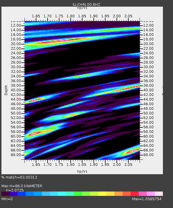
| Estimated Moho Depth: |
66.0 km |
| Estimated Crust Vp/Vs: |
2.07 |
| Assumed Crust Vp: |
4.24 km/s |
| Estimated Crust Vs: |
2.046 km/s |
| Estimated Crust Poisson's Ratio: |
0.35 |
|
| Radial Match: |
83.00312 % |
| Radial Bump: |
324 |
| Transverse Match: |
57.877167 % |
| Transverse Bump: |
400 |
| SOD ConfigId: |
590571 |
| Insert Time: |
2013-09-24 19:09:53.040 +0000 |
| GWidth: |
2.5 |
| Max Bumps: |
400 |
| Tol: |
0.001 |
|

Signal To Noise
| Channel | StoN | STA | LTA |
| IU:JOHN:00:BHZ:20001004T17:05:42.472994Z | 2.1202607 | 1.1869034E-5 | 5.597913E-6 |
| IU:JOHN:00:BH1:20001004T17:05:42.472994Z | 2.7906456 | 9.174024E-6 | 3.28742E-6 |
| IU:JOHN:00:BH2:20001004T17:05:42.472994Z | 2.2135804 | 8.269764E-6 | 3.7359225E-6 |
| Arrivals |
| Ps | 17 SECOND |
| PpPs | 47 SECOND |
| PsPs/PpSs | 64 SECOND |


