You are here: Home > Network List > II - Global Seismograph Network (GSN - IRIS/IDA) Stations List
> Station MBAR Mbarara, Uganda > Earthquake Result Viewer
MBAR Mbarara, Uganda - Earthquake Result Viewer

| Earthquake location: |
Sumba Region, Indonesia |
| Earthquake latitude/longitude: |
-10.0/119.4 |
| Earthquake time(UTC): |
2000/10/07 (281) 11:57:40 GMT |
| Earthquake Depth: |
33 km |
| Earthquake Magnitude: |
5.8 MB, 5.6 MS, 5.9 MW, 5.8 MW |
| Earthquake Catalog/Contributor: |
WHDF/NEIC |
|
| Network: |
II Global Seismograph Network (GSN - IRIS/IDA) |
| Station: |
MBAR Mbarara, Uganda |
| Lat/Lon: |
0.60 S/30.74 E |
| Elevation: |
1390 m |
|
| Distance: |
88.6 deg |
| Az: |
269.645 deg |
| Baz: |
99.897 deg |
| Ray Param: |
0.042455517 |
| Estimated Moho Depth: |
65.25 km |
| Estimated Crust Vp/Vs: |
1.70 |
| Assumed Crust Vp: |
6.419 km/s |
| Estimated Crust Vs: |
3.787 km/s |
| Estimated Crust Poisson's Ratio: |
0.23 |
|
| Radial Match: |
81.35665 % |
| Radial Bump: |
400 |
| Transverse Match: |
60.010582 % |
| Transverse Bump: |
400 |
| SOD ConfigId: |
590571 |
| Insert Time: |
2013-09-24 19:11:05.507 +0000 |
| GWidth: |
2.5 |
| Max Bumps: |
400 |
| Tol: |
0.001 |
|
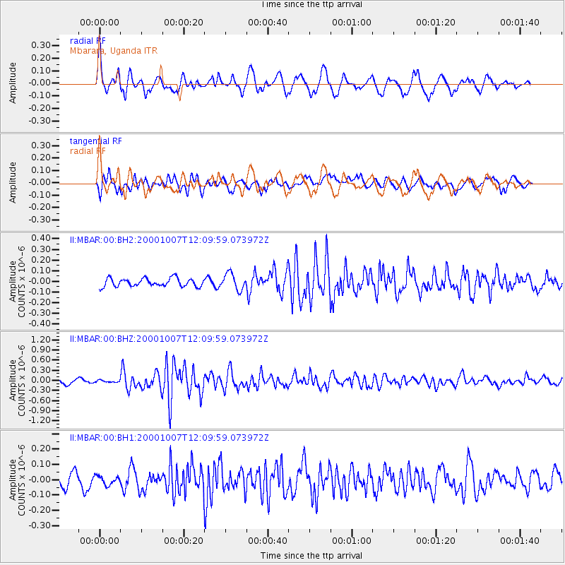
Signal To Noise
| Channel | StoN | STA | LTA |
| II:MBAR:00:BHZ:20001007T12:09:59.073972Z | 0.41646942 | 2.8391874E-8 | 6.8172774E-8 |
| II:MBAR:00:BH1:20001007T12:09:59.073972Z | 0.5437504 | 3.5508155E-8 | 6.530231E-8 |
| II:MBAR:00:BH2:20001007T12:09:59.073972Z | 2.0741012 | 7.843404E-8 | 3.781592E-8 |
| Arrivals |
| Ps | 7.2 SECOND |
| PpPs | 27 SECOND |
| PsPs/PpSs | 34 SECOND |


