You are here: Home > Network List > IU - Global Seismograph Network (GSN - IRIS/USGS) Stations List
> Station RSSD Black Hills, South Dakota, USA > Earthquake Result Viewer
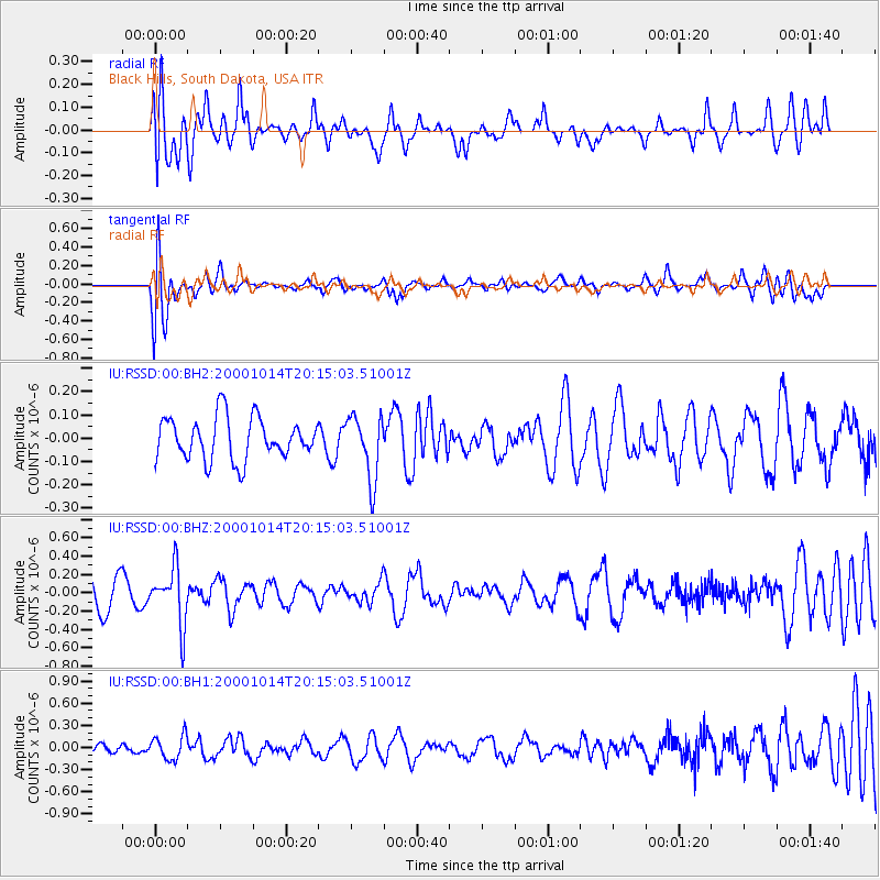
RSSD Black Hills, South Dakota, USA - Earthquake Result Viewer
*The percent match for this event was below the threshold and hence no stack was calculated.
| Earthquake location: |
Volcano Islands, Japan Region |
| Earthquake latitude/longitude: |
23.6/141.8 |
| Earthquake time(UTC): |
2000/10/14 (288) 20:02:52 GMT |
| Earthquake Depth: |
138 km |
| Earthquake Magnitude: |
5.6 MB |
| Earthquake Catalog/Contributor: |
WHDF/NEIC |
|
| Network: |
IU Global Seismograph Network (GSN - IRIS/USGS) |
| Station: |
RSSD Black Hills, South Dakota, USA |
| Lat/Lon: |
44.12 N/104.04 W |
| Elevation: |
2060 m |
|
| Distance: |
89.7 deg |
| Az: |
41.093 deg |
| Baz: |
303.126 deg |
| Ray Param: |
$rayparam |
*The percent match for this event was below the threshold and hence was not used in the summary stack. |
|
| Radial Match: |
51.119488 % |
| Radial Bump: |
400 |
| Transverse Match: |
58.89375 % |
| Transverse Bump: |
400 |
| SOD ConfigId: |
590571 |
| Insert Time: |
2013-09-24 19:13:18.142 +0000 |
| GWidth: |
2.5 |
| Max Bumps: |
400 |
| Tol: |
0.001 |
|
Signal To Noise
| Channel | StoN | STA | LTA |
| IU:RSSD:00:BHZ:20001014T20:15:03.51001Z | 2.394853 | 3.0654405E-7 | 1.2800119E-7 |
| IU:RSSD:00:BH1:20001014T20:15:03.51001Z | 1.7246757 | 1.6212887E-7 | 9.400543E-8 |
| IU:RSSD:00:BH2:20001014T20:15:03.51001Z | 1.5292101 | 1.373067E-7 | 8.97893E-8 |
| Arrivals |
| Ps | |
| PpPs | |
| PsPs/PpSs | |


