You are here: Home > Network List > IU - Global Seismograph Network (GSN - IRIS/USGS) Stations List
> Station TEIG Tepich, Yucatan, Mexico > Earthquake Result Viewer
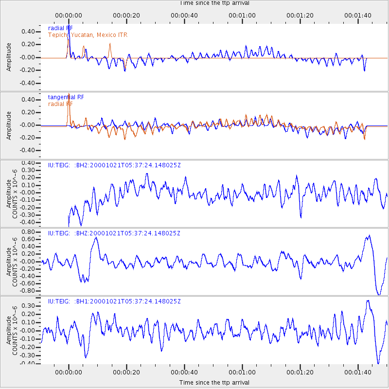
TEIG Tepich, Yucatan, Mexico - Earthquake Result Viewer
*The percent match for this event was below the threshold and hence no stack was calculated.
| Earthquake location: |
Tonga Islands |
| Earthquake latitude/longitude: |
-17.3/-175.2 |
| Earthquake time(UTC): |
2000/10/21 (295) 05:25:14 GMT |
| Earthquake Depth: |
292 km |
| Earthquake Magnitude: |
6.3 MW |
| Earthquake Catalog/Contributor: |
NEIC PDE/NEIC PDE-M |
|
| Network: |
IU Global Seismograph Network (GSN - IRIS/USGS) |
| Station: |
TEIG Tepich, Yucatan, Mexico |
| Lat/Lon: |
20.23 N/88.28 W |
| Elevation: |
69 m |
|
| Distance: |
93.0 deg |
| Az: |
69.889 deg |
| Baz: |
252.812 deg |
| Ray Param: |
$rayparam |
*The percent match for this event was below the threshold and hence was not used in the summary stack. |
|
| Radial Match: |
56.56814 % |
| Radial Bump: |
400 |
| Transverse Match: |
50.97723 % |
| Transverse Bump: |
400 |
| SOD ConfigId: |
590571 |
| Insert Time: |
2013-09-24 19:14:27.550 +0000 |
| GWidth: |
2.5 |
| Max Bumps: |
400 |
| Tol: |
0.001 |
|
Signal To Noise
| Channel | StoN | STA | LTA |
| IU:TEIG: :BHZ:20001021T05:37:24.148025Z | 2.473746 | 2.3800445E-7 | 9.6212155E-8 |
| IU:TEIG: :BH1:20001021T05:37:24.148025Z | 1.0187334 | 9.946009E-8 | 9.763112E-8 |
| IU:TEIG: :BH2:20001021T05:37:24.148025Z | 1.0822284 | 1.6504735E-7 | 1.5250694E-7 |
| Arrivals |
| Ps | |
| PpPs | |
| PsPs/PpSs | |


