You are here: Home > Network List > IU - Global Seismograph Network (GSN - IRIS/USGS) Stations List
> Station RSSD Black Hills, South Dakota, USA > Earthquake Result Viewer
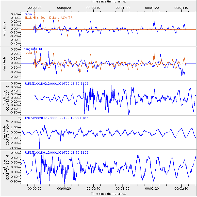
RSSD Black Hills, South Dakota, USA - Earthquake Result Viewer
*The percent match for this event was below the threshold and hence no stack was calculated.
| Earthquake location: |
East Of Kuril Islands |
| Earthquake latitude/longitude: |
47.8/155.7 |
| Earthquake time(UTC): |
2000/10/29 (303) 22:03:56 GMT |
| Earthquake Depth: |
50 km |
| Earthquake Magnitude: |
5.7 MB, 5.5 MW |
| Earthquake Catalog/Contributor: |
NEIC PDE/NEIC PDE-M |
|
| Network: |
IU Global Seismograph Network (GSN - IRIS/USGS) |
| Station: |
RSSD Black Hills, South Dakota, USA |
| Lat/Lon: |
44.12 N/104.04 W |
| Elevation: |
2060 m |
|
| Distance: |
64.8 deg |
| Az: |
51.527 deg |
| Baz: |
312.851 deg |
| Ray Param: |
$rayparam |
*The percent match for this event was below the threshold and hence was not used in the summary stack. |
|
| Radial Match: |
66.53419 % |
| Radial Bump: |
400 |
| Transverse Match: |
68.345345 % |
| Transverse Bump: |
400 |
| SOD ConfigId: |
590571 |
| Insert Time: |
2013-09-24 19:19:49.809 +0000 |
| GWidth: |
2.5 |
| Max Bumps: |
400 |
| Tol: |
0.001 |
|
Signal To Noise
| Channel | StoN | STA | LTA |
| IU:RSSD:00:BHZ:20001029T22:13:59.810Z | 2.609435 | 7.7699514E-7 | 2.9776373E-7 |
| IU:RSSD:00:BH1:20001029T22:13:59.810Z | 2.488969 | 6.281634E-7 | 2.5237892E-7 |
| IU:RSSD:00:BH2:20001029T22:13:59.810Z | 2.8799136 | 2.9198827E-7 | 1.0138786E-7 |
| Arrivals |
| Ps | |
| PpPs | |
| PsPs/PpSs | |


