You are here: Home > Network List > CN - Canadian National Seismograph Network Stations List
> Station SADO SADOWA, ON, CANADA CANADA > Earthquake Result Viewer
SADO SADOWA, ON, CANADA CANADA - Earthquake Result Viewer
| Earthquake location: |
Jujuy Province, Argentina |
| Earthquake latitude/longitude: |
-22.2/-65.8 |
| Earthquake time(UTC): |
2007/07/21 (202) 15:34:52 GMT |
| Earthquake Depth: |
290 km |
| Earthquake Magnitude: |
5.8 MB, 6.4 MW, 6.3 MW |
| Earthquake Catalog/Contributor: |
WHDF/NEIC |
|
| Network: |
CN Canadian National Seismograph Network |
| Station: |
SADO SADOWA, ON, CANADA CANADA |
| Lat/Lon: |
44.77 N/79.14 W |
| Elevation: |
243 m |
|
| Distance: |
67.7 deg |
| Az: |
349.75 deg |
| Baz: |
166.608 deg |
| Ray Param: |
0.055905268 |
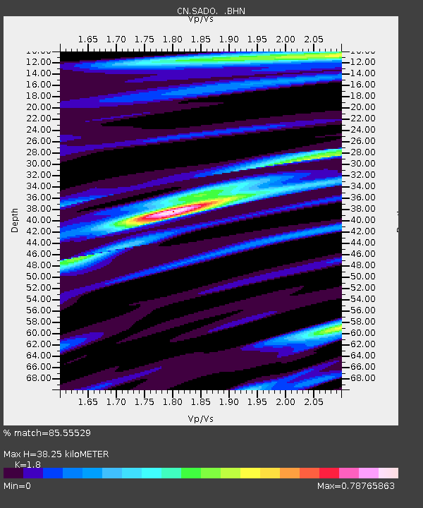
| Estimated Moho Depth: |
38.25 km |
| Estimated Crust Vp/Vs: |
1.80 |
| Assumed Crust Vp: |
6.577 km/s |
| Estimated Crust Vs: |
3.654 km/s |
| Estimated Crust Poisson's Ratio: |
0.28 |
|
| Radial Match: |
85.55529 % |
| Radial Bump: |
314 |
| Transverse Match: |
62.977036 % |
| Transverse Bump: |
400 |
| SOD ConfigId: |
2564 |
| Insert Time: |
2010-02-27 07:16:51.100 +0000 |
| GWidth: |
2.5 |
| Max Bumps: |
400 |
| Tol: |
0.001 |
|
Signal To Noise
| Channel | StoN | STA | LTA |
| CN:SADO: :BHN:20070721T15:44:48.175012Z | 1.893654 | 1.464114E-7 | 7.731686E-8 |
| CN:SADO: :BHE:20070721T15:44:48.175012Z | 0.9585198 | 9.457307E-8 | 9.866574E-8 |
| CN:SADO: :BHZ:20070721T15:44:48.175012Z | 3.2733908 | 3.3540258E-7 | 1.02463346E-7 |
| Arrivals |
| Ps | 4.8 SECOND |
| PpPs | 16 SECOND |
| PsPs/PpSs | 20 SECOND |


