You are here: Home > Network List > II - Global Seismograph Network (GSN - IRIS/IDA) Stations List
> Station MBAR Mbarara, Uganda > Earthquake Result Viewer
MBAR Mbarara, Uganda - Earthquake Result Viewer
| Earthquake location: |
Northern Algeria |
| Earthquake latitude/longitude: |
36.6/4.8 |
| Earthquake time(UTC): |
2000/11/10 (315) 20:10:53 GMT |
| Earthquake Depth: |
10 km |
| Earthquake Magnitude: |
5.7 MW, 5.5 ME, 5.5 MS, 5.8 MB |
| Earthquake Catalog/Contributor: |
NEIC PDE/NEIC PDE-M |
|
| Network: |
II Global Seismograph Network (GSN - IRIS/IDA) |
| Station: |
MBAR Mbarara, Uganda |
| Lat/Lon: |
0.60 S/30.74 E |
| Elevation: |
1390 m |
|
| Distance: |
44.2 deg |
| Az: |
141.076 deg |
| Baz: |
329.627 deg |
| Ray Param: |
0.072080515 |
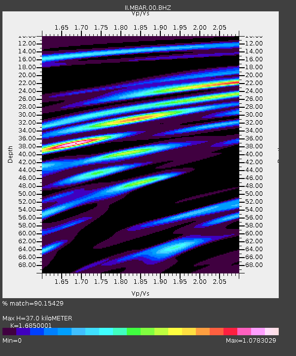
| Estimated Moho Depth: |
37.0 km |
| Estimated Crust Vp/Vs: |
1.69 |
| Assumed Crust Vp: |
6.419 km/s |
| Estimated Crust Vs: |
3.81 km/s |
| Estimated Crust Poisson's Ratio: |
0.23 |
|
| Radial Match: |
90.15429 % |
| Radial Bump: |
379 |
| Transverse Match: |
76.184906 % |
| Transverse Bump: |
400 |
| SOD ConfigId: |
590571 |
| Insert Time: |
2013-09-24 19:25:39.234 +0000 |
| GWidth: |
2.5 |
| Max Bumps: |
400 |
| Tol: |
0.001 |
|

Signal To Noise
| Channel | StoN | STA | LTA |
| II:MBAR:00:BHZ:20001110T20:18:31.333013Z | 20.945574 | 6.7109687E-7 | 3.2040035E-8 |
| II:MBAR:00:BH1:20001110T20:18:31.333013Z | 7.7951765 | 3.7090453E-7 | 4.758129E-8 |
| II:MBAR:00:BH2:20001110T20:18:31.333013Z | 7.218115 | 2.9206333E-7 | 4.046255E-8 |
| Arrivals |
| Ps | 4.2 SECOND |
| PpPs | 14 SECOND |
| PsPs/PpSs | 19 SECOND |


