You are here: Home > Network List > AK - Alaska Regional Network Stations List
> Station CHI Chirikof Island > Earthquake Result Viewer
CHI Chirikof Island - Earthquake Result Viewer
| Earthquake location: |
Talaud Islands, Indonesia |
| Earthquake latitude/longitude: |
4.7/126.5 |
| Earthquake time(UTC): |
2014/09/19 (262) 02:57:35 GMT |
| Earthquake Depth: |
80 km |
| Earthquake Magnitude: |
5.0 MW |
| Earthquake Catalog/Contributor: |
ISC/ISC |
|
| Network: |
AK Alaska Regional Network |
| Station: |
CHI Chirikof Island |
| Lat/Lon: |
55.82 N/155.62 W |
| Elevation: |
234 m |
|
| Distance: |
79.3 deg |
| Az: |
34.158 deg |
| Baz: |
262.563 deg |
| Ray Param: |
0.04889525 |
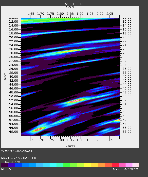
| Estimated Moho Depth: |
52.0 km |
| Estimated Crust Vp/Vs: |
1.88 |
| Assumed Crust Vp: |
3.999 km/s |
| Estimated Crust Vs: |
2.13 km/s |
| Estimated Crust Poisson's Ratio: |
0.30 |
|
| Radial Match: |
82.29603 % |
| Radial Bump: |
400 |
| Transverse Match: |
64.42517 % |
| Transverse Bump: |
400 |
| SOD ConfigId: |
3390531 |
| Insert Time: |
2019-04-14 02:55:54.816 +0000 |
| GWidth: |
2.5 |
| Max Bumps: |
400 |
| Tol: |
0.001 |
|

Signal To Noise
| Channel | StoN | STA | LTA |
| AK:CHI: :BHZ:20140919T03:09:01.48802Z | 0.96379876 | 2.866614E-6 | 2.9742869E-6 |
| AK:CHI: :BHN:20140919T03:09:01.48802Z | 0.85157984 | 1.259871E-6 | 1.4794514E-6 |
| AK:CHI: :BHE:20140919T03:09:01.48802Z | 1.3806397 | 3.8028859E-6 | 2.7544377E-6 |
| Arrivals |
| Ps | 12 SECOND |
| PpPs | 37 SECOND |
| PsPs/PpSs | 49 SECOND |


