You are here: Home > Network List > CN - Canadian National Seismograph Network Stations List
> Station SADO SADOWA, ON, CANADA CANADA > Earthquake Result Viewer
SADO SADOWA, ON, CANADA CANADA - Earthquake Result Viewer
| Earthquake location: |
Peru-Brazil Border Region |
| Earthquake latitude/longitude: |
-7.9/-74.4 |
| Earthquake time(UTC): |
2007/07/12 (193) 05:23:49 GMT |
| Earthquake Depth: |
152 km |
| Earthquake Magnitude: |
5.9 MB, 6.1 MW, 6.0 MW |
| Earthquake Catalog/Contributor: |
WHDF/NEIC |
|
| Network: |
CN Canadian National Seismograph Network |
| Station: |
SADO SADOWA, ON, CANADA CANADA |
| Lat/Lon: |
44.77 N/79.14 W |
| Elevation: |
243 m |
|
| Distance: |
52.6 deg |
| Az: |
355.732 deg |
| Baz: |
174.06 deg |
| Ray Param: |
0.06611015 |
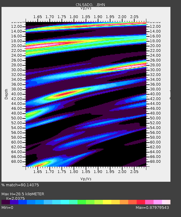
| Estimated Moho Depth: |
28.5 km |
| Estimated Crust Vp/Vs: |
2.04 |
| Assumed Crust Vp: |
6.577 km/s |
| Estimated Crust Vs: |
3.228 km/s |
| Estimated Crust Poisson's Ratio: |
0.34 |
|
| Radial Match: |
90.14075 % |
| Radial Bump: |
400 |
| Transverse Match: |
80.68695 % |
| Transverse Bump: |
400 |
| SOD ConfigId: |
2564 |
| Insert Time: |
2010-02-27 07:17:06.424 +0000 |
| GWidth: |
2.5 |
| Max Bumps: |
400 |
| Tol: |
0.001 |
|
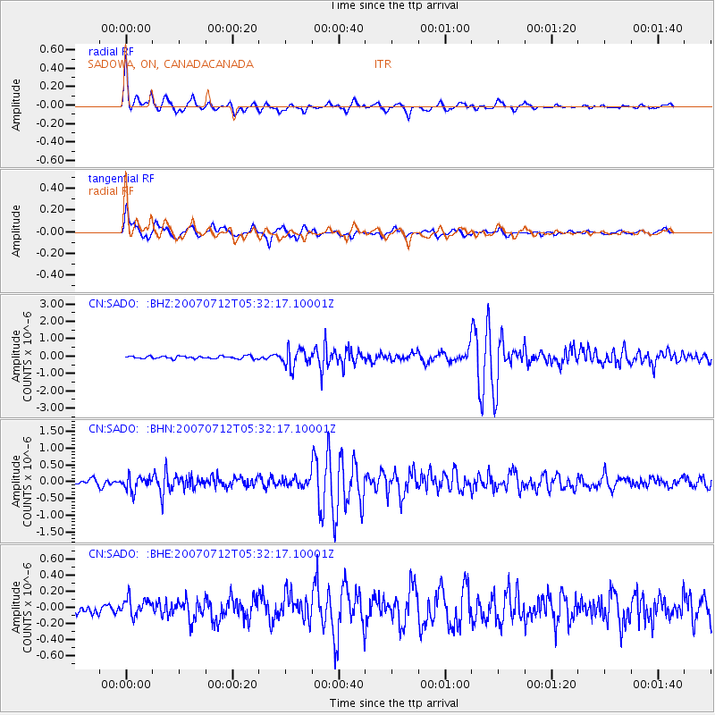
Signal To Noise
| Channel | StoN | STA | LTA |
| CN:SADO: :BHN:20070712T05:32:17.10001Z | 2.3328586 | 2.163647E-7 | 9.27466E-8 |
| CN:SADO: :BHE:20070712T05:32:17.10001Z | 1.6941643 | 1.1220634E-7 | 6.623108E-8 |
| CN:SADO: :BHZ:20070712T05:32:17.10001Z | 6.8044558 | 5.288819E-7 | 7.772582E-8 |
| Arrivals |
| Ps | 4.7 SECOND |
| PpPs | 13 SECOND |
| PsPs/PpSs | 17 SECOND |


