You are here: Home > Network List > II - Global Seismograph Network (GSN - IRIS/IDA) Stations List
> Station MBAR Mbarara, Uganda > Earthquake Result Viewer
MBAR Mbarara, Uganda - Earthquake Result Viewer
| Earthquake location: |
Eastern Caucasus |
| Earthquake latitude/longitude: |
40.2/49.9 |
| Earthquake time(UTC): |
2000/11/25 (330) 18:09:11 GMT |
| Earthquake Depth: |
50 km |
| Earthquake Magnitude: |
5.8 MB, 6.3 MW |
| Earthquake Catalog/Contributor: |
WHDF/NEIC |
|
| Network: |
II Global Seismograph Network (GSN - IRIS/IDA) |
| Station: |
MBAR Mbarara, Uganda |
| Lat/Lon: |
0.60 S/30.74 E |
| Elevation: |
1390 m |
|
| Distance: |
44.3 deg |
| Az: |
208.118 deg |
| Baz: |
21.147 deg |
| Ray Param: |
0.07188874 |
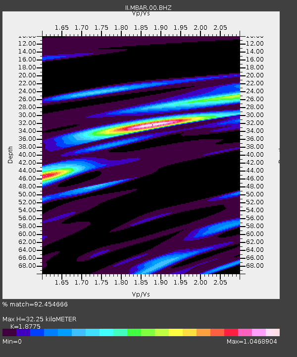
| Estimated Moho Depth: |
32.25 km |
| Estimated Crust Vp/Vs: |
1.88 |
| Assumed Crust Vp: |
6.419 km/s |
| Estimated Crust Vs: |
3.419 km/s |
| Estimated Crust Poisson's Ratio: |
0.30 |
|
| Radial Match: |
92.454666 % |
| Radial Bump: |
319 |
| Transverse Match: |
74.54392 % |
| Transverse Bump: |
400 |
| SOD ConfigId: |
590571 |
| Insert Time: |
2013-09-24 19:41:31.750 +0000 |
| GWidth: |
2.5 |
| Max Bumps: |
400 |
| Tol: |
0.001 |
|
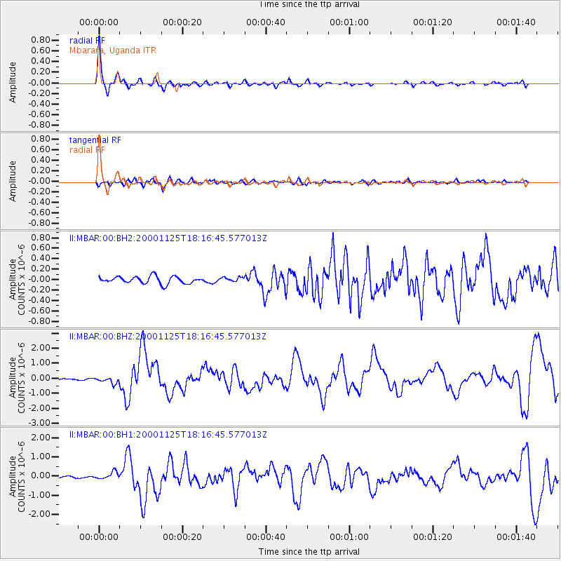
Signal To Noise
| Channel | StoN | STA | LTA |
| II:MBAR:00:BHZ:20001125T18:16:45.577013Z | 2.4538496 | 2.2469776E-7 | 9.15695E-8 |
| II:MBAR:00:BH1:20001125T18:16:45.577013Z | 5.2404327 | 1.982771E-7 | 3.7836017E-8 |
| II:MBAR:00:BH2:20001125T18:16:45.577013Z | 0.61152947 | 4.138453E-8 | 6.767381E-8 |
| Arrivals |
| Ps | 4.7 SECOND |
| PpPs | 14 SECOND |
| PsPs/PpSs | 18 SECOND |


