You are here: Home > Network List > IU - Global Seismograph Network (GSN - IRIS/USGS) Stations List
> Station TEIG Tepich, Yucatan, Mexico > Earthquake Result Viewer
TEIG Tepich, Yucatan, Mexico - Earthquake Result Viewer
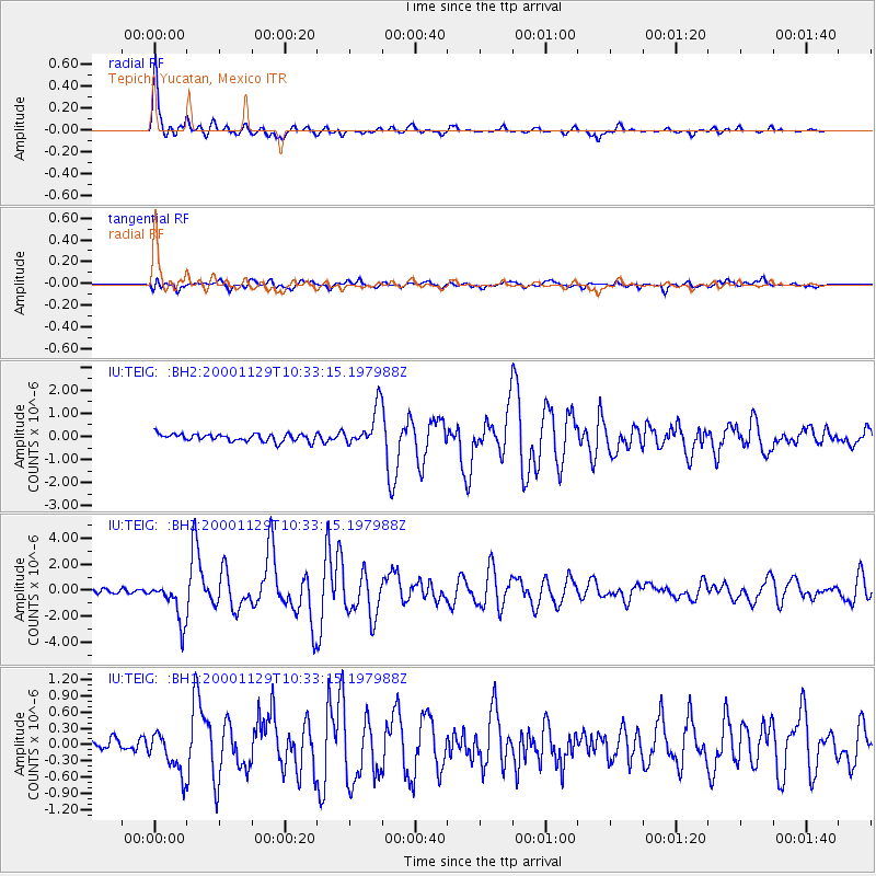
| Earthquake location: |
Near Coast Of Northern Chile |
| Earthquake latitude/longitude: |
-24.9/-70.9 |
| Earthquake time(UTC): |
2000/11/29 (334) 10:25:13 GMT |
| Earthquake Depth: |
58 km |
| Earthquake Magnitude: |
5.8 MB, 5.9 MS, 6.4 MW, 6.3 MW |
| Earthquake Catalog/Contributor: |
WHDF/NEIC |
|
| Network: |
IU Global Seismograph Network (GSN - IRIS/USGS) |
| Station: |
TEIG Tepich, Yucatan, Mexico |
| Lat/Lon: |
20.23 N/88.28 W |
| Elevation: |
69 m |
|
| Distance: |
47.9 deg |
| Az: |
337.777 deg |
| Baz: |
158.541 deg |
| Ray Param: |
0.06953441 |
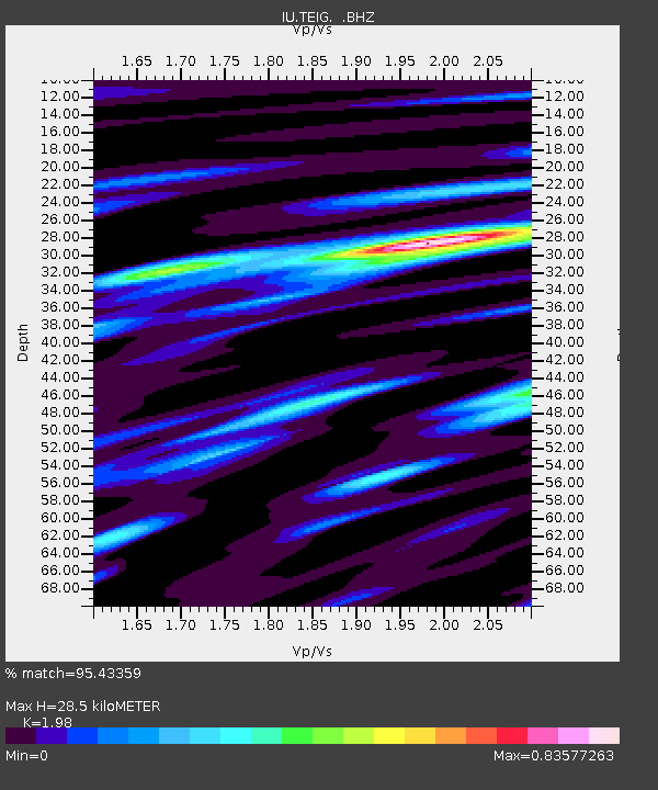
| Estimated Moho Depth: |
28.5 km |
| Estimated Crust Vp/Vs: |
1.98 |
| Assumed Crust Vp: |
5.817 km/s |
| Estimated Crust Vs: |
2.938 km/s |
| Estimated Crust Poisson's Ratio: |
0.33 |
|
| Radial Match: |
95.43359 % |
| Radial Bump: |
382 |
| Transverse Match: |
74.39589 % |
| Transverse Bump: |
400 |
| SOD ConfigId: |
590571 |
| Insert Time: |
2013-09-24 19:43:21.886 +0000 |
| GWidth: |
2.5 |
| Max Bumps: |
400 |
| Tol: |
0.001 |
|
Signal To Noise
| Channel | StoN | STA | LTA |
| IU:TEIG: :BHZ:20001129T10:33:15.197988Z | 8.568728 | 1.5599984E-6 | 1.8205716E-7 |
| IU:TEIG: :BH1:20001129T10:33:15.197988Z | 2.069538 | 3.5901272E-7 | 1.7347479E-7 |
| IU:TEIG: :BH2:20001129T10:33:15.197988Z | 5.1909523 | 8.312692E-7 | 1.6013809E-7 |
| Arrivals |
| Ps | 5.0 SECOND |
| PpPs | 14 SECOND |
| PsPs/PpSs | 19 SECOND |


