You are here: Home > Network List > PF - Volcanologic Network of Piton de Fournaise-OVPF Stations List
> Station GPS Grandes Pentes Sud > Earthquake Result Viewer
GPS Grandes Pentes Sud - Earthquake Result Viewer
*The percent match for this event was below the threshold and hence no stack was calculated.
| Earthquake location: |
Talaud Islands, Indonesia |
| Earthquake latitude/longitude: |
4.7/126.5 |
| Earthquake time(UTC): |
2014/09/19 (262) 02:57:35 GMT |
| Earthquake Depth: |
80 km |
| Earthquake Magnitude: |
5.0 MW |
| Earthquake Catalog/Contributor: |
ISC/ISC |
|
| Network: |
PF Volcanologic Network of Piton de Fournaise-OVPF |
| Station: |
GPS Grandes Pentes Sud |
| Lat/Lon: |
21.27 S/55.76 E |
| Elevation: |
1004 m |
|
| Distance: |
73.9 deg |
| Az: |
246.415 deg |
| Baz: |
78.319 deg |
| Ray Param: |
$rayparam |
*The percent match for this event was below the threshold and hence was not used in the summary stack. |
|
| Radial Match: |
38.725494 % |
| Radial Bump: |
400 |
| Transverse Match: |
22.458065 % |
| Transverse Bump: |
400 |
| SOD ConfigId: |
3390531 |
| Insert Time: |
2019-04-14 02:57:35.144 +0000 |
| GWidth: |
2.5 |
| Max Bumps: |
400 |
| Tol: |
0.001 |
|
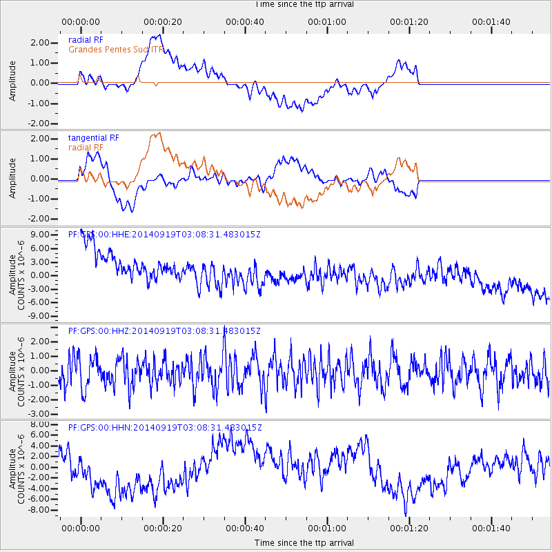
Signal To Noise
| Channel | StoN | STA | LTA |
| PF:GPS:00:HHZ:20140919T03:08:31.483015Z | 1.2999556 | 1.1264634E-6 | 8.6653995E-7 |
| PF:GPS:00:HHN:20140919T03:08:31.483015Z | 1.0009997 | 3.0528504E-6 | 3.0498015E-6 |
| PF:GPS:00:HHE:20140919T03:08:31.483015Z | 1.428517 | 4.215293E-6 | 2.9508174E-6 |
| Arrivals |
| Ps | |
| PpPs | |
| PsPs/PpSs | |


