You are here: Home > Network List > CN - Canadian National Seismograph Network Stations List
> Station SADO SADOWA, ON, CANADA CANADA > Earthquake Result Viewer
SADO SADOWA, ON, CANADA CANADA - Earthquake Result Viewer
| Earthquake location: |
Southeast Of Honshu, Japan |
| Earthquake latitude/longitude: |
32.8/140.4 |
| Earthquake time(UTC): |
2009/08/12 (224) 22:48:51 GMT |
| Earthquake Depth: |
53 km |
| Earthquake Magnitude: |
6.2 MB, 6.6 MW, 6.6 MW |
| Earthquake Catalog/Contributor: |
WHDF/NEIC |
|
| Network: |
CN Canadian National Seismograph Network |
| Station: |
SADO SADOWA, ON, CANADA CANADA |
| Lat/Lon: |
44.77 N/79.14 W |
| Elevation: |
243 m |
|
| Distance: |
94.8 deg |
| Az: |
27.068 deg |
| Baz: |
327.459 deg |
| Ray Param: |
0.040916745 |
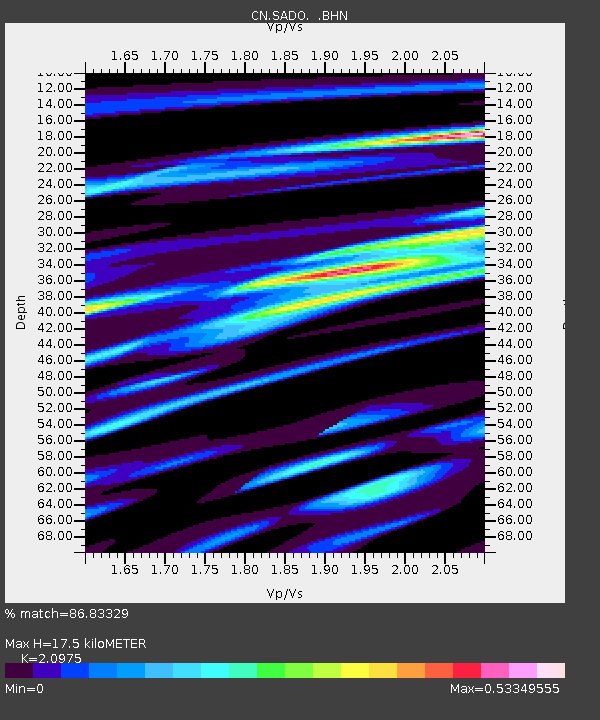
| Estimated Moho Depth: |
17.5 km |
| Estimated Crust Vp/Vs: |
2.10 |
| Assumed Crust Vp: |
6.577 km/s |
| Estimated Crust Vs: |
3.136 km/s |
| Estimated Crust Poisson's Ratio: |
0.35 |
|
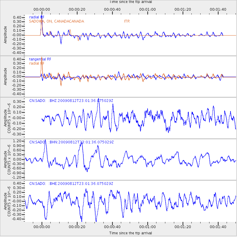
| Radial Match: |
86.83329 % |
| Radial Bump: |
400 |
| Transverse Match: |
64.10196 % |
| Transverse Bump: |
400 |
| SOD ConfigId: |
2622 |
| Insert Time: |
2010-02-27 07:17:19.404 +0000 |
| GWidth: |
2.5 |
| Max Bumps: |
400 |
| Tol: |
0.001 |
|
Signal To Noise
| Channel | StoN | STA | LTA |
| CN:SADO: :BHN:20090812T23:01:36.075029Z | 6.9299593 | 5.714256E-7 | 8.245728E-8 |
| CN:SADO: :BHE:20090812T23:01:36.075029Z | 2.435712 | 2.0481994E-7 | 8.409038E-8 |
| CN:SADO: :BHZ:20090812T23:01:36.075029Z | 2.2699916 | 1.7028682E-7 | 7.5016494E-8 |
| Arrivals |
| Ps | 3.0 SECOND |
| PpPs | 8.1 SECOND |
| PsPs/PpSs | 11 SECOND |


