You are here: Home > Network List > IU - Global Seismograph Network (GSN - IRIS/USGS) Stations List
> Station RSSD Black Hills, South Dakota, USA > Earthquake Result Viewer
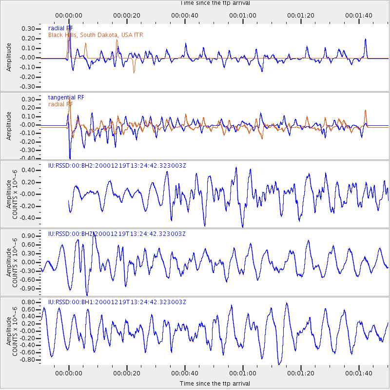
RSSD Black Hills, South Dakota, USA - Earthquake Result Viewer
*The percent match for this event was below the threshold and hence no stack was calculated.
| Earthquake location: |
South Of Mariana Islands |
| Earthquake latitude/longitude: |
11.8/144.8 |
| Earthquake time(UTC): |
2000/12/19 (354) 13:11:47 GMT |
| Earthquake Depth: |
33 km |
| Earthquake Magnitude: |
6.3 MB, 5.8 MS, 6.2 MW, 6.2 MW |
| Earthquake Catalog/Contributor: |
WHDF/NEIC |
|
| Network: |
IU Global Seismograph Network (GSN - IRIS/USGS) |
| Station: |
RSSD Black Hills, South Dakota, USA |
| Lat/Lon: |
44.12 N/104.04 W |
| Elevation: |
2060 m |
|
| Distance: |
96.6 deg |
| Az: |
42.524 deg |
| Baz: |
293.217 deg |
| Ray Param: |
$rayparam |
*The percent match for this event was below the threshold and hence was not used in the summary stack. |
|
| Radial Match: |
51.37079 % |
| Radial Bump: |
400 |
| Transverse Match: |
61.571625 % |
| Transverse Bump: |
400 |
| SOD ConfigId: |
590571 |
| Insert Time: |
2013-09-24 19:50:40.386 +0000 |
| GWidth: |
2.5 |
| Max Bumps: |
400 |
| Tol: |
0.001 |
|
Signal To Noise
| Channel | StoN | STA | LTA |
| IU:RSSD:00:BHZ:20001219T13:24:42.323003Z | 1.8312582 | 5.901468E-7 | 3.2226302E-7 |
| IU:RSSD:00:BH1:20001219T13:24:42.323003Z | 1.0123874 | 3.11638E-7 | 3.0782485E-7 |
| IU:RSSD:00:BH2:20001219T13:24:42.323003Z | 1.7133453 | 1.8943223E-7 | 1.1056279E-7 |
| Arrivals |
| Ps | |
| PpPs | |
| PsPs/PpSs | |


