You are here: Home > Network List > IU - Global Seismograph Network (GSN - IRIS/USGS) Stations List
> Station RSSD Black Hills, South Dakota, USA > Earthquake Result Viewer
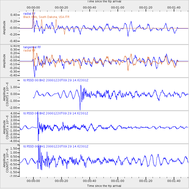
RSSD Black Hills, South Dakota, USA - Earthquake Result Viewer
*The percent match for this event was below the threshold and hence no stack was calculated.
| Earthquake location: |
Near East Coast Of Kamchatka |
| Earthquake latitude/longitude: |
53.4/159.8 |
| Earthquake time(UTC): |
2000/12/20 (355) 09:19:50 GMT |
| Earthquake Depth: |
67 km |
| Earthquake Magnitude: |
5.5 MB |
| Earthquake Catalog/Contributor: |
NEIC PDE/NEIC PDE-M |
|
| Network: |
IU Global Seismograph Network (GSN - IRIS/USGS) |
| Station: |
RSSD Black Hills, South Dakota, USA |
| Lat/Lon: |
44.12 N/104.04 W |
| Elevation: |
2060 m |
|
| Distance: |
59.4 deg |
| Az: |
56.342 deg |
| Baz: |
316.231 deg |
| Ray Param: |
$rayparam |
*The percent match for this event was below the threshold and hence was not used in the summary stack. |
|
| Radial Match: |
60.293907 % |
| Radial Bump: |
400 |
| Transverse Match: |
71.78465 % |
| Transverse Bump: |
400 |
| SOD ConfigId: |
590571 |
| Insert Time: |
2013-09-24 19:50:56.317 +0000 |
| GWidth: |
2.5 |
| Max Bumps: |
400 |
| Tol: |
0.001 |
|
Signal To Noise
| Channel | StoN | STA | LTA |
| IU:RSSD:00:BHZ:20001220T09:29:14.62301Z | 3.7161598 | 1.2003393E-6 | 3.2300528E-7 |
| IU:RSSD:00:BH1:20001220T09:29:14.62301Z | 2.815373 | 5.8384876E-7 | 2.0737883E-7 |
| IU:RSSD:00:BH2:20001220T09:29:14.62301Z | 2.7655087 | 7.411563E-7 | 2.68E-7 |
| Arrivals |
| Ps | |
| PpPs | |
| PsPs/PpSs | |


