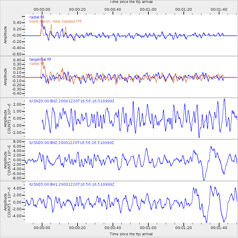
SNZO South Karori, New Zealand - Earthquake Result Viewer
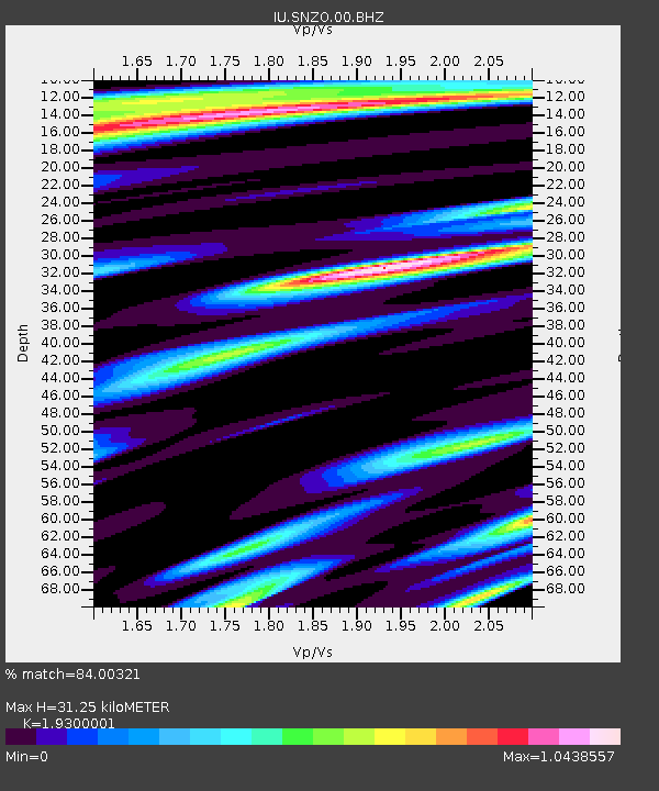
Earthquake location: D'Entrecasteaux Islands Region
Earthquake latitude/longitude: -9.2/154.4
Earthquake time(UTC): 2000/12/20 (355) 16:49:43 GMT
Earthquake Depth: 33 km
Earthquake Magnitude: 5.8 MB, 6.3 MS, 6.6 MW, 6.5 MW
Earthquake Catalog/Contributor: WHDF/NEIC
Network: IU Global Seismograph Network (GSN - IRIS/USGS)
Station: SNZO South Karori, New Zealand
Lat/Lon: 41.31 S/174.70 E
Elevation: 62 m
Distance: 36.7 deg
Az: 153.979 deg
Baz: 324.907 deg
Ray Param: 0.07649317
Estimated Moho Depth: 31.25 km
Estimated Crust Vp/Vs: 1.93
Assumed Crust Vp: 6.461 km/s
Estimated Crust Vs: 3.348 km/s
Estimated Crust Poisson's Ratio: 0.32
Radial Match: 84.00321 %
Radial Bump: 400
Transverse Match: 57.17565 %
Transverse Bump: 400
SOD ConfigId: 590571
Insert Time: 2013-09-24 19:51:46.525 +0000
GWidth: 2.5
Max Bumps: 400
Tol: 0.001

Signal To Noise

ChannelStoNSTALTA
IU:SNZO:00:BHZ:20001220T16:56:16.510999Z3.34539911.7983592E-65.375619E-7
IU:SNZO:00:BH1:20001220T16:56:16.510999Z1.42870221.1561901E-68.09259E-7
IU:SNZO:00:BH2:20001220T16:56:16.510999Z0.829166777.116335E-78.582514E-7
Arrivals
Ps4.8 SECOND
PpPs13 SECOND
PsPs/PpSs18 SECOND