You are here: Home > Network List > IU - Global Seismograph Network (GSN - IRIS/USGS) Stations List
> Station RSSD Black Hills, South Dakota, USA > Earthquake Result Viewer
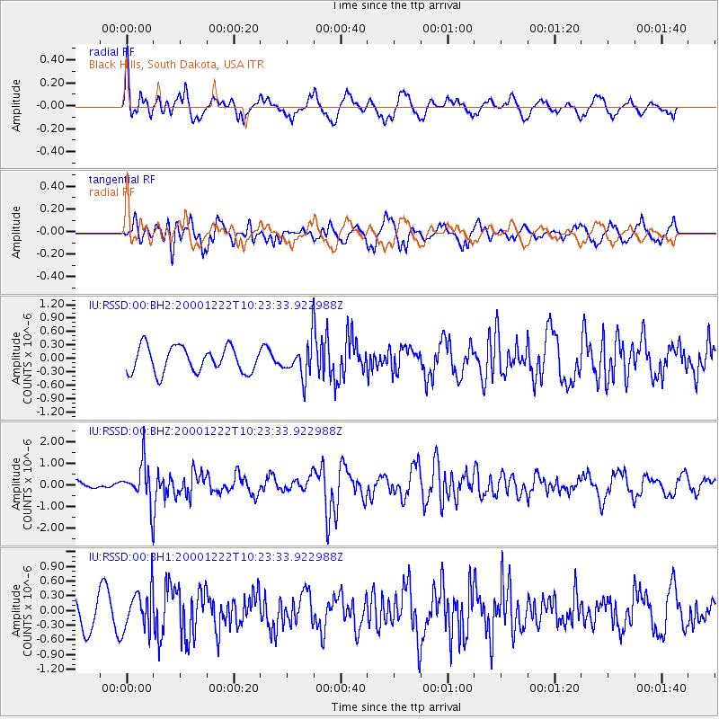
RSSD Black Hills, South Dakota, USA - Earthquake Result Viewer
*The percent match for this event was below the threshold and hence no stack was calculated.
| Earthquake location: |
Kuril Islands |
| Earthquake latitude/longitude: |
44.8/147.2 |
| Earthquake time(UTC): |
2000/12/22 (357) 10:13:01 GMT |
| Earthquake Depth: |
140 km |
| Earthquake Magnitude: |
6.0 MB, 6.2 MW, 6.2 MW |
| Earthquake Catalog/Contributor: |
WHDF/NEIC |
|
| Network: |
IU Global Seismograph Network (GSN - IRIS/USGS) |
| Station: |
RSSD Black Hills, South Dakota, USA |
| Lat/Lon: |
44.12 N/104.04 W |
| Elevation: |
2060 m |
|
| Distance: |
71.2 deg |
| Az: |
46.08 deg |
| Baz: |
314.59 deg |
| Ray Param: |
$rayparam |
*The percent match for this event was below the threshold and hence was not used in the summary stack. |
|
| Radial Match: |
73.34053 % |
| Radial Bump: |
400 |
| Transverse Match: |
72.35562 % |
| Transverse Bump: |
400 |
| SOD ConfigId: |
590571 |
| Insert Time: |
2013-09-24 19:53:52.322 +0000 |
| GWidth: |
2.5 |
| Max Bumps: |
400 |
| Tol: |
0.001 |
|
Signal To Noise
| Channel | StoN | STA | LTA |
| IU:RSSD:00:BHZ:20001222T10:23:33.922988Z | 3.8191426 | 9.119037E-7 | 2.3877183E-7 |
| IU:RSSD:00:BH1:20001222T10:23:33.922988Z | 1.09667 | 4.1579807E-7 | 3.79146E-7 |
| IU:RSSD:00:BH2:20001222T10:23:33.922988Z | 1.3740264 | 3.902852E-7 | 2.8404492E-7 |
| Arrivals |
| Ps | |
| PpPs | |
| PsPs/PpSs | |


