You are here: Home > Network List > IU - Global Seismograph Network (GSN - IRIS/USGS) Stations List
> Station JOHN Johnston Island, USA > Earthquake Result Viewer
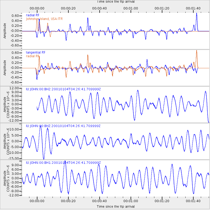
JOHN Johnston Island, USA - Earthquake Result Viewer
*The percent match for this event was below the threshold and hence no stack was calculated.
| Earthquake location: |
Eastern Honshu, Japan |
| Earthquake latitude/longitude: |
37.0/138.6 |
| Earthquake time(UTC): |
2001/01/04 (004) 04:18:21 GMT |
| Earthquake Depth: |
21 km |
| Earthquake Magnitude: |
5.5 MB |
| Earthquake Catalog/Contributor: |
NEIC PDE/NEIC PDE-M |
|
| Network: |
IU Global Seismograph Network (GSN - IRIS/USGS) |
| Station: |
JOHN Johnston Island, USA |
| Lat/Lon: |
16.73 N/169.53 W |
| Elevation: |
2.0 m |
|
| Distance: |
49.8 deg |
| Az: |
99.454 deg |
| Baz: |
304.476 deg |
| Ray Param: |
$rayparam |
*The percent match for this event was below the threshold and hence was not used in the summary stack. |
|
| Radial Match: |
66.04853 % |
| Radial Bump: |
364 |
| Transverse Match: |
52.414745 % |
| Transverse Bump: |
387 |
| SOD ConfigId: |
590571 |
| Insert Time: |
2013-09-24 19:57:19.482 +0000 |
| GWidth: |
2.5 |
| Max Bumps: |
400 |
| Tol: |
0.001 |
|
Signal To Noise
| Channel | StoN | STA | LTA |
| IU:JOHN:00:BHZ:20010104T04:26:41.709999Z | 2.2713032 | 9.37064E-6 | 4.1256667E-6 |
| IU:JOHN:00:BH1:20010104T04:26:41.709999Z | 0.53562564 | 2.8291151E-6 | 5.281889E-6 |
| IU:JOHN:00:BH2:20010104T04:26:41.709999Z | 1.0344635 | 4.7877265E-6 | 4.628222E-6 |
| Arrivals |
| Ps | |
| PpPs | |
| PsPs/PpSs | |


