You are here: Home > Network List > IU - Global Seismograph Network (GSN - IRIS/USGS) Stations List
> Station JOHN Johnston Island, USA > Earthquake Result Viewer
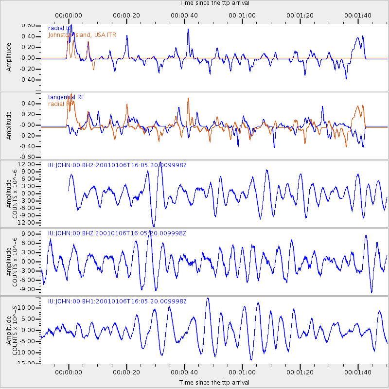
JOHN Johnston Island, USA - Earthquake Result Viewer
*The percent match for this event was below the threshold and hence no stack was calculated.
| Earthquake location: |
Philippine Islands Region |
| Earthquake latitude/longitude: |
5.8/127.3 |
| Earthquake time(UTC): |
2001/01/06 (006) 15:55:31 GMT |
| Earthquake Depth: |
53 km |
| Earthquake Magnitude: |
5.5 MS, 5.7 MW |
| Earthquake Catalog/Contributor: |
NEIC PDE/NEIC PDE-M |
|
| Network: |
IU Global Seismograph Network (GSN - IRIS/USGS) |
| Station: |
JOHN Johnston Island, USA |
| Lat/Lon: |
16.73 N/169.53 W |
| Elevation: |
2.0 m |
|
| Distance: |
62.6 deg |
| Az: |
74.262 deg |
| Baz: |
267.951 deg |
| Ray Param: |
$rayparam |
*The percent match for this event was below the threshold and hence was not used in the summary stack. |
|
| Radial Match: |
52.111973 % |
| Radial Bump: |
400 |
| Transverse Match: |
45.400093 % |
| Transverse Bump: |
400 |
| SOD ConfigId: |
590571 |
| Insert Time: |
2013-09-24 19:58:56.938 +0000 |
| GWidth: |
2.5 |
| Max Bumps: |
400 |
| Tol: |
0.001 |
|
Signal To Noise
| Channel | StoN | STA | LTA |
| IU:JOHN:00:BHZ:20010106T16:05:20.009998Z | 1.0449262 | 3.6949625E-6 | 3.536099E-6 |
| IU:JOHN:00:BH1:20010106T16:05:20.009998Z | 0.41621634 | 1.7581552E-6 | 4.2241377E-6 |
| IU:JOHN:00:BH2:20010106T16:05:20.009998Z | 2.681515 | 8.515887E-6 | 3.175775E-6 |
| Arrivals |
| Ps | |
| PpPs | |
| PsPs/PpSs | |


