You are here: Home > Network List > IU - Global Seismograph Network (GSN - IRIS/USGS) Stations List
> Station JOHN Johnston Island, USA > Earthquake Result Viewer
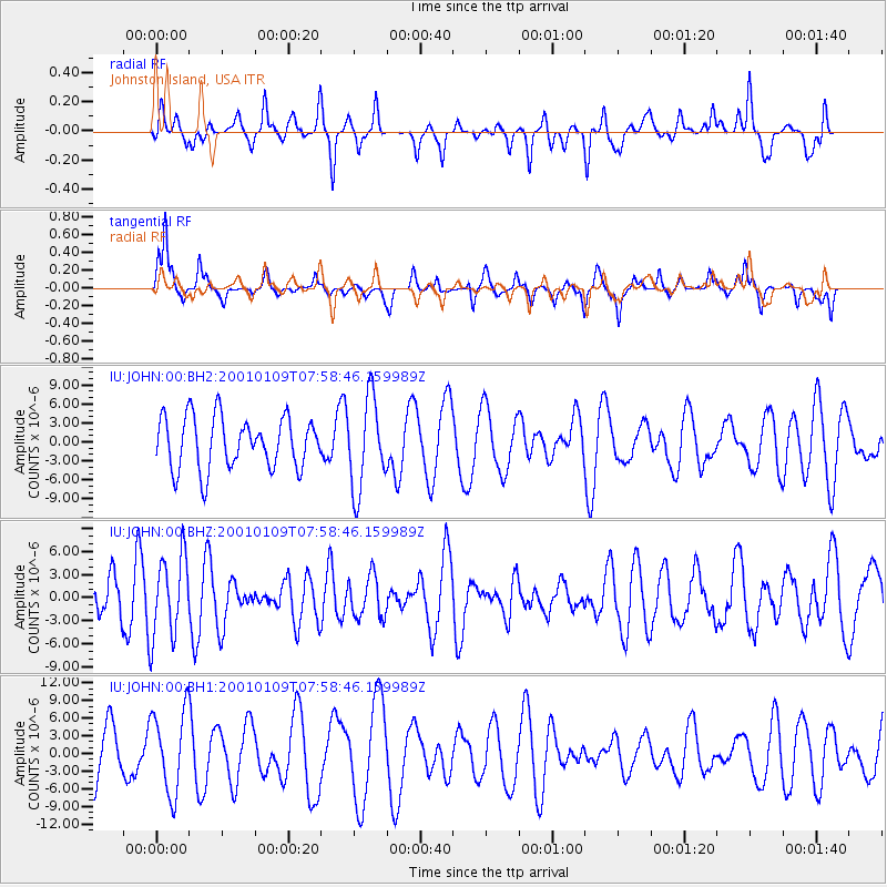
JOHN Johnston Island, USA - Earthquake Result Viewer
*The percent match for this event was below the threshold and hence no stack was calculated.
| Earthquake location: |
Fiji Islands Region |
| Earthquake latitude/longitude: |
-18.5/176.1 |
| Earthquake time(UTC): |
2001/01/09 (009) 07:52:03 GMT |
| Earthquake Depth: |
33 km |
| Earthquake Magnitude: |
5.5 MW, 5.6 MW |
| Earthquake Catalog/Contributor: |
NEIC PDE/NEIC PDE-M |
|
| Network: |
IU Global Seismograph Network (GSN - IRIS/USGS) |
| Station: |
JOHN Johnston Island, USA |
| Lat/Lon: |
16.73 N/169.53 W |
| Elevation: |
2.0 m |
|
| Distance: |
37.8 deg |
| Az: |
22.924 deg |
| Baz: |
202.692 deg |
| Ray Param: |
$rayparam |
*The percent match for this event was below the threshold and hence was not used in the summary stack. |
|
| Radial Match: |
47.2715 % |
| Radial Bump: |
305 |
| Transverse Match: |
55.34669 % |
| Transverse Bump: |
307 |
| SOD ConfigId: |
590571 |
| Insert Time: |
2013-09-24 19:59:41.891 +0000 |
| GWidth: |
2.5 |
| Max Bumps: |
400 |
| Tol: |
0.001 |
|
Signal To Noise
| Channel | StoN | STA | LTA |
| IU:JOHN:00:BHZ:20010109T07:58:46.159989Z | 1.5390545 | 5.2560463E-6 | 3.415114E-6 |
| IU:JOHN:00:BH1:20010109T07:58:46.159989Z | 1.0465837 | 7.044655E-6 | 6.731096E-6 |
| IU:JOHN:00:BH2:20010109T07:58:46.159989Z | 1.7553674 | 7.1764252E-6 | 4.0882755E-6 |
| Arrivals |
| Ps | |
| PpPs | |
| PsPs/PpSs | |


