You are here: Home > Network List > IU - Global Seismograph Network (GSN - IRIS/USGS) Stations List
> Station JOHN Johnston Island, USA > Earthquake Result Viewer
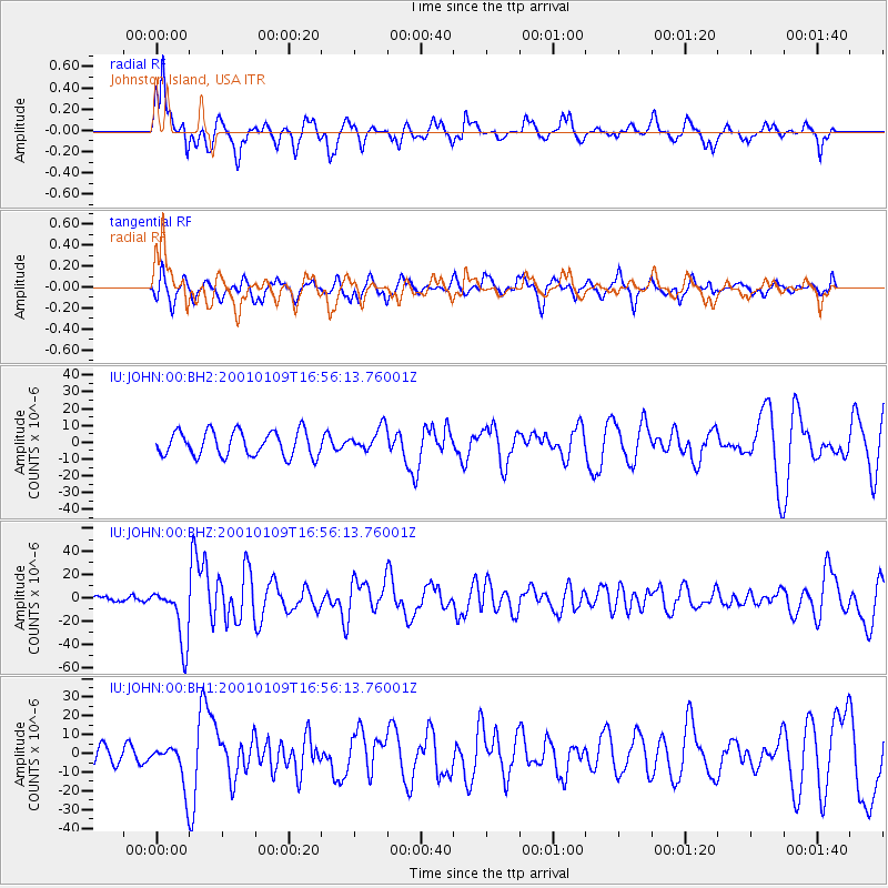
JOHN Johnston Island, USA - Earthquake Result Viewer
*The percent match for this event was below the threshold and hence no stack was calculated.
| Earthquake location: |
Vanuatu Islands |
| Earthquake latitude/longitude: |
-14.9/167.2 |
| Earthquake time(UTC): |
2001/01/09 (009) 16:49:28 GMT |
| Earthquake Depth: |
103 km |
| Earthquake Magnitude: |
6.3 MB, 6.6 MS, 7.6 ME, 7.0 MW |
| Earthquake Catalog/Contributor: |
WHDF/NEIC |
|
| Network: |
IU Global Seismograph Network (GSN - IRIS/USGS) |
| Station: |
JOHN Johnston Island, USA |
| Lat/Lon: |
16.73 N/169.53 W |
| Elevation: |
2.0 m |
|
| Distance: |
39.0 deg |
| Az: |
37.059 deg |
| Baz: |
217.444 deg |
| Ray Param: |
$rayparam |
*The percent match for this event was below the threshold and hence was not used in the summary stack. |
|
| Radial Match: |
79.559814 % |
| Radial Bump: |
328 |
| Transverse Match: |
61.26599 % |
| Transverse Bump: |
400 |
| SOD ConfigId: |
590571 |
| Insert Time: |
2013-09-24 19:59:55.463 +0000 |
| GWidth: |
2.5 |
| Max Bumps: |
400 |
| Tol: |
0.001 |
|
Signal To Noise
| Channel | StoN | STA | LTA |
| IU:JOHN:00:BHZ:20010109T16:56:13.76001Z | 5.0422845 | 2.4961195E-5 | 4.9503747E-6 |
| IU:JOHN:00:BH1:20010109T16:56:13.76001Z | 1.9460115 | 1.1058397E-5 | 5.6825957E-6 |
| IU:JOHN:00:BH2:20010109T16:56:13.76001Z | 0.96641093 | 7.1374097E-6 | 7.385481E-6 |
| Arrivals |
| Ps | |
| PpPs | |
| PsPs/PpSs | |


