You are here: Home > Network List > IU - Global Seismograph Network (GSN - IRIS/USGS) Stations List
> Station RAR Rarotonga, Cook Islands > Earthquake Result Viewer
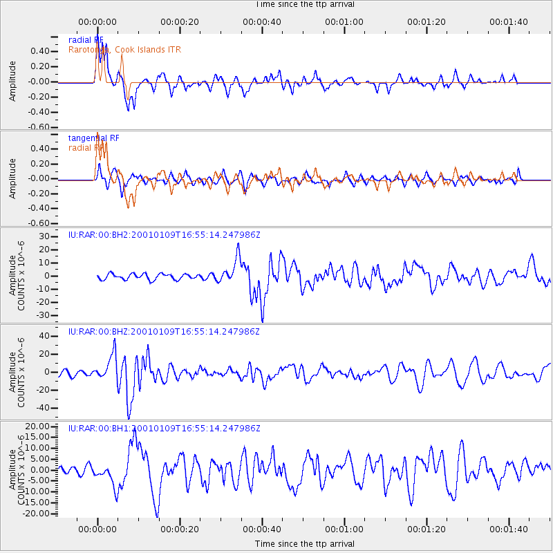
RAR Rarotonga, Cook Islands - Earthquake Result Viewer

| Earthquake location: |
Vanuatu Islands |
| Earthquake latitude/longitude: |
-14.9/167.2 |
| Earthquake time(UTC): |
2001/01/09 (009) 16:49:28 GMT |
| Earthquake Depth: |
103 km |
| Earthquake Magnitude: |
6.3 MB, 6.6 MS, 7.6 ME, 7.0 MW |
| Earthquake Catalog/Contributor: |
WHDF/NEIC |
|
| Network: |
IU Global Seismograph Network (GSN - IRIS/USGS) |
| Station: |
RAR Rarotonga, Cook Islands |
| Lat/Lon: |
21.21 S/159.77 W |
| Elevation: |
28 m |
|
| Distance: |
32.0 deg |
| Az: |
106.166 deg |
| Baz: |
275.695 deg |
| Ray Param: |
0.07856583 |
| Estimated Moho Depth: |
10.25 km |
| Estimated Crust Vp/Vs: |
1.61 |
| Assumed Crust Vp: |
4.24 km/s |
| Estimated Crust Vs: |
2.642 km/s |
| Estimated Crust Poisson's Ratio: |
0.18 |
|
| Radial Match: |
87.83337 % |
| Radial Bump: |
400 |
| Transverse Match: |
70.43459 % |
| Transverse Bump: |
400 |
| SOD ConfigId: |
590571 |
| Insert Time: |
2013-09-24 19:59:57.788 +0000 |
| GWidth: |
2.5 |
| Max Bumps: |
400 |
| Tol: |
0.001 |
|
Signal To Noise
| Channel | StoN | STA | LTA |
| IU:RAR:00:BHZ:20010109T16:55:14.247986Z | 6.181607 | 1.4689567E-5 | 2.3763348E-6 |
| IU:RAR:00:BH1:20010109T16:55:14.247986Z | 2.0073884 | 5.264795E-6 | 2.6227087E-6 |
| IU:RAR:00:BH2:20010109T16:55:14.247986Z | 4.621382 | 9.796915E-6 | 2.11991E-6 |
| Arrivals |
| Ps | 1.5 SECOND |
| PpPs | 6.1 SECOND |
| PsPs/PpSs | 7.6 SECOND |


