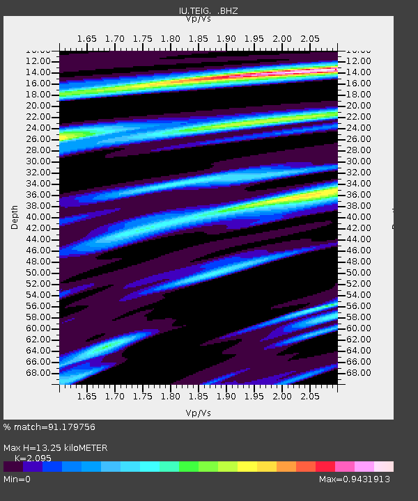
TEIG Tepich, Yucatan, Mexico - Earthquake Result Viewer

Earthquake location: Kodiak Island Region, Alaska
Earthquake latitude/longitude: 57.1/-153.2
Earthquake time(UTC): 2001/01/10 (010) 16:02:44 GMT
Earthquake Depth: 33 km
Earthquake Magnitude: 6.2 MB, 6.8 MS, 7.1 MW, 6.8 ML
Earthquake Catalog/Contributor: WHDF/NEIC
Network: IU Global Seismograph Network (GSN - IRIS/USGS)
Station: TEIG Tepich, Yucatan, Mexico
Lat/Lon: 20.23 N/88.28 W
Elevation: 69 m
Distance: 59.7 deg
Az: 99.714 deg
Baz: 325.029 deg
Ray Param: 0.061987333
Estimated Moho Depth: 13.25 km
Estimated Crust Vp/Vs: 2.10
Assumed Crust Vp: 5.817 km/s
Estimated Crust Vs: 2.777 km/s
Estimated Crust Poisson's Ratio: 0.35
Radial Match: 91.179756 %
Radial Bump: 353
Transverse Match: 46.736355 %
Transverse Bump: 400
SOD ConfigId: 590571
Insert Time: 2013-09-24 20:00:12.965 +0000
GWidth: 2.5
Max Bumps: 400
Tol: 0.001

Signal To Noise

ChannelStoNSTALTA
IU:TEIG: :BHZ:20010110T16:12:14.435994Z2.88516528.194435E-72.8401962E-7
IU:TEIG: :BH1:20010110T16:12:14.435994Z0.97489325.9690046E-76.122727E-7
IU:TEIG: :BH2:20010110T16:12:14.435994Z2.22334345.2572204E-72.3645563E-7
Arrivals
Ps2.6 SECOND
PpPs6.8 SECOND
PsPs/PpSs9.4 SECOND