You are here: Home > Network List > IU - Global Seismograph Network (GSN - IRIS/USGS) Stations List
> Station RSSD Black Hills, South Dakota, USA > Earthquake Result Viewer
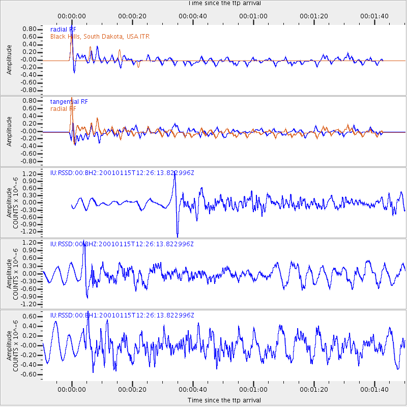
RSSD Black Hills, South Dakota, USA - Earthquake Result Viewer
*The percent match for this event was below the threshold and hence no stack was calculated.
| Earthquake location: |
El Salvador |
| Earthquake latitude/longitude: |
13.1/-88.6 |
| Earthquake time(UTC): |
2001/01/15 (015) 12:20:10 GMT |
| Earthquake Depth: |
75 km |
| Earthquake Magnitude: |
5.8 MW |
| Earthquake Catalog/Contributor: |
NEIC PDE/NEIC PDE-M |
|
| Network: |
IU Global Seismograph Network (GSN - IRIS/USGS) |
| Station: |
RSSD Black Hills, South Dakota, USA |
| Lat/Lon: |
44.12 N/104.04 W |
| Elevation: |
2060 m |
|
| Distance: |
33.7 deg |
| Az: |
339.738 deg |
| Baz: |
152.061 deg |
| Ray Param: |
$rayparam |
*The percent match for this event was below the threshold and hence was not used in the summary stack. |
|
| Radial Match: |
68.35422 % |
| Radial Bump: |
400 |
| Transverse Match: |
50.35813 % |
| Transverse Bump: |
400 |
| SOD ConfigId: |
590571 |
| Insert Time: |
2013-09-24 20:03:26.896 +0000 |
| GWidth: |
2.5 |
| Max Bumps: |
400 |
| Tol: |
0.001 |
|
Signal To Noise
| Channel | StoN | STA | LTA |
| IU:RSSD:00:BHZ:20010115T12:26:13.822996Z | 2.327642 | 5.1621873E-7 | 2.2177754E-7 |
| IU:RSSD:00:BH1:20010115T12:26:13.822996Z | 0.74659336 | 1.8243333E-7 | 2.4435434E-7 |
| IU:RSSD:00:BH2:20010115T12:26:13.822996Z | 4.0254397 | 4.9122525E-7 | 1.2203022E-7 |
| Arrivals |
| Ps | |
| PpPs | |
| PsPs/PpSs | |


