You are here: Home > Network List > IU - Global Seismograph Network (GSN - IRIS/USGS) Stations List
> Station RSSD Black Hills, South Dakota, USA > Earthquake Result Viewer
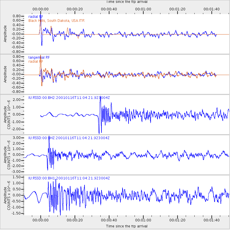
RSSD Black Hills, South Dakota, USA - Earthquake Result Viewer
*The percent match for this event was below the threshold and hence no stack was calculated.
| Earthquake location: |
Off Coast Of Central America |
| Earthquake latitude/longitude: |
13.0/-88.7 |
| Earthquake time(UTC): |
2001/01/16 (016) 10:58:17 GMT |
| Earthquake Depth: |
63 km |
| Earthquake Magnitude: |
5.6 MW, 5.7 MW |
| Earthquake Catalog/Contributor: |
NEIC PDE/NEIC PDE-M |
|
| Network: |
IU Global Seismograph Network (GSN - IRIS/USGS) |
| Station: |
RSSD Black Hills, South Dakota, USA |
| Lat/Lon: |
44.12 N/104.04 W |
| Elevation: |
2060 m |
|
| Distance: |
33.7 deg |
| Az: |
339.92 deg |
| Baz: |
152.31 deg |
| Ray Param: |
$rayparam |
*The percent match for this event was below the threshold and hence was not used in the summary stack. |
|
| Radial Match: |
73.94027 % |
| Radial Bump: |
400 |
| Transverse Match: |
72.28284 % |
| Transverse Bump: |
400 |
| SOD ConfigId: |
590571 |
| Insert Time: |
2013-09-24 20:03:55.650 +0000 |
| GWidth: |
2.5 |
| Max Bumps: |
400 |
| Tol: |
0.001 |
|
Signal To Noise
| Channel | StoN | STA | LTA |
| IU:RSSD:00:BHZ:20010116T11:04:21.923004Z | 3.4073515 | 7.075451E-7 | 2.0765252E-7 |
| IU:RSSD:00:BH1:20010116T11:04:21.923004Z | 2.8142643 | 3.661178E-7 | 1.3009361E-7 |
| IU:RSSD:00:BH2:20010116T11:04:21.923004Z | 5.2271495 | 7.6512566E-7 | 1.4637531E-7 |
| Arrivals |
| Ps | |
| PpPs | |
| PsPs/PpSs | |


