You are here: Home > Network List > IU - Global Seismograph Network (GSN - IRIS/USGS) Stations List
> Station RSSD Black Hills, South Dakota, USA > Earthquake Result Viewer
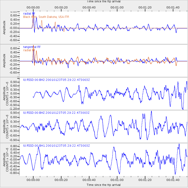
RSSD Black Hills, South Dakota, USA - Earthquake Result Viewer
*The percent match for this event was below the threshold and hence no stack was calculated.
| Earthquake location: |
Guatemala |
| Earthquake latitude/longitude: |
14.0/-90.9 |
| Earthquake time(UTC): |
2001/01/23 (023) 05:23:32 GMT |
| Earthquake Depth: |
64 km |
| Earthquake Magnitude: |
5.5 MB, 5.9 MW, 5.9 MW |
| Earthquake Catalog/Contributor: |
WHDF/NEIC |
|
| Network: |
IU Global Seismograph Network (GSN - IRIS/USGS) |
| Station: |
RSSD Black Hills, South Dakota, USA |
| Lat/Lon: |
44.12 N/104.04 W |
| Elevation: |
2060 m |
|
| Distance: |
32.0 deg |
| Az: |
342.035 deg |
| Baz: |
155.439 deg |
| Ray Param: |
$rayparam |
*The percent match for this event was below the threshold and hence was not used in the summary stack. |
|
| Radial Match: |
57.731342 % |
| Radial Bump: |
400 |
| Transverse Match: |
57.390842 % |
| Transverse Bump: |
400 |
| SOD ConfigId: |
590571 |
| Insert Time: |
2013-09-24 20:06:09.626 +0000 |
| GWidth: |
2.5 |
| Max Bumps: |
400 |
| Tol: |
0.001 |
|
Signal To Noise
| Channel | StoN | STA | LTA |
| IU:RSSD:00:BHZ:20010123T05:29:22.473003Z | 1.0777732 | 1.6471921E-7 | 1.5283291E-7 |
| IU:RSSD:00:BH1:20010123T05:29:22.473003Z | 2.028455 | 4.5854694E-7 | 2.2605725E-7 |
| IU:RSSD:00:BH2:20010123T05:29:22.473003Z | 1.3790566 | 3.1118435E-7 | 2.2565017E-7 |
| Arrivals |
| Ps | |
| PpPs | |
| PsPs/PpSs | |


