You are here: Home > Network List > IU - Global Seismograph Network (GSN - IRIS/USGS) Stations List
> Station RSSD Black Hills, South Dakota, USA > Earthquake Result Viewer
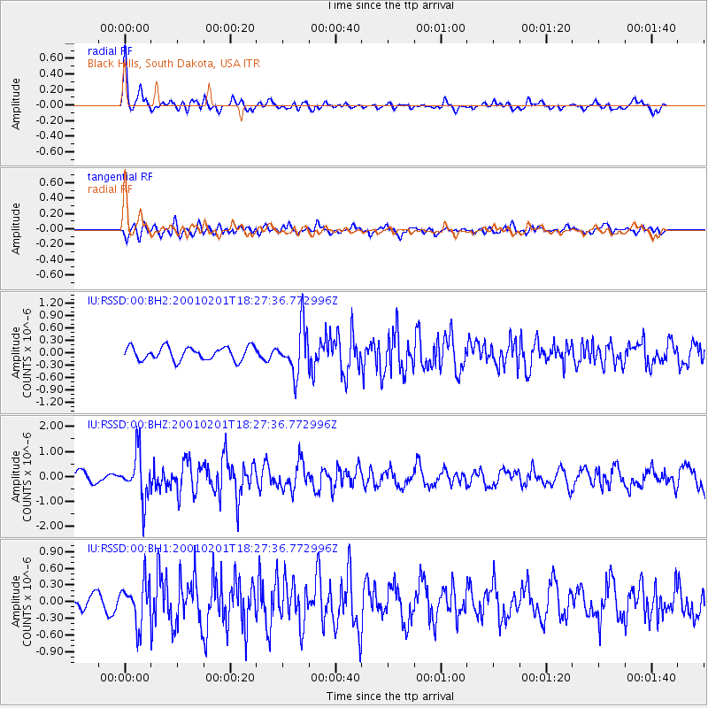
RSSD Black Hills, South Dakota, USA - Earthquake Result Viewer
*The percent match for this event was below the threshold and hence no stack was calculated.
| Earthquake location: |
Andreanof Islands, Aleutian Is. |
| Earthquake latitude/longitude: |
51.4/-177.8 |
| Earthquake time(UTC): |
2001/02/01 (032) 18:19:30 GMT |
| Earthquake Depth: |
33 km |
| Earthquake Magnitude: |
5.6 MB, 5.6 MS, 6.0 MW, 5.9 MW |
| Earthquake Catalog/Contributor: |
WHDF/NEIC |
|
| Network: |
IU Global Seismograph Network (GSN - IRIS/USGS) |
| Station: |
RSSD Black Hills, South Dakota, USA |
| Lat/Lon: |
44.12 N/104.04 W |
| Elevation: |
2060 m |
|
| Distance: |
48.2 deg |
| Az: |
68.157 deg |
| Baz: |
306.225 deg |
| Ray Param: |
$rayparam |
*The percent match for this event was below the threshold and hence was not used in the summary stack. |
|
| Radial Match: |
76.51379 % |
| Radial Bump: |
400 |
| Transverse Match: |
55.37697 % |
| Transverse Bump: |
400 |
| SOD ConfigId: |
590571 |
| Insert Time: |
2013-09-24 20:10:21.749 +0000 |
| GWidth: |
2.5 |
| Max Bumps: |
400 |
| Tol: |
0.001 |
|
Signal To Noise
| Channel | StoN | STA | LTA |
| IU:RSSD:00:BHZ:20010201T18:27:36.772996Z | 5.432865 | 9.2071497E-7 | 1.6947135E-7 |
| IU:RSSD:00:BH1:20010201T18:27:36.772996Z | 3.3586593 | 3.825716E-7 | 1.13906054E-7 |
| IU:RSSD:00:BH2:20010201T18:27:36.772996Z | 3.6091204 | 5.696058E-7 | 1.5782399E-7 |
| Arrivals |
| Ps | |
| PpPs | |
| PsPs/PpSs | |


