You are here: Home > Network List > II - Global Seismograph Network (GSN - IRIS/IDA) Stations List
> Station PALK Pallekele, Sri Lanka > Earthquake Result Viewer
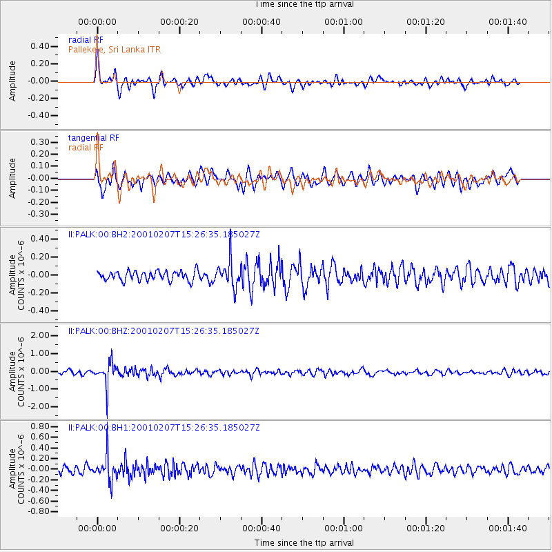
PALK Pallekele, Sri Lanka - Earthquake Result Viewer
*The percent match for this event was below the threshold and hence no stack was calculated.
| Earthquake location: |
Northwest Of Kuril Islands |
| Earthquake latitude/longitude: |
52.8/153.8 |
| Earthquake time(UTC): |
2001/02/07 (038) 15:16:15 GMT |
| Earthquake Depth: |
427 km |
| Earthquake Magnitude: |
5.6 MB, 5.8 MW, 5.7 MW |
| Earthquake Catalog/Contributor: |
WHDF/NEIC |
|
| Network: |
II Global Seismograph Network (GSN - IRIS/IDA) |
| Station: |
PALK Pallekele, Sri Lanka |
| Lat/Lon: |
7.27 N/80.70 E |
| Elevation: |
460 m |
|
| Distance: |
74.1 deg |
| Az: |
260.907 deg |
| Baz: |
37.23 deg |
| Ray Param: |
$rayparam |
*The percent match for this event was below the threshold and hence was not used in the summary stack. |
|
| Radial Match: |
60.262222 % |
| Radial Bump: |
400 |
| Transverse Match: |
61.00378 % |
| Transverse Bump: |
400 |
| SOD ConfigId: |
590571 |
| Insert Time: |
2013-09-24 20:11:26.425 +0000 |
| GWidth: |
2.5 |
| Max Bumps: |
400 |
| Tol: |
0.001 |
|
Signal To Noise
| Channel | StoN | STA | LTA |
| II:PALK:00:BHZ:20010207T15:26:35.185027Z | 6.9696407 | 6.7878744E-7 | 9.739203E-8 |
| II:PALK:00:BH1:20010207T15:26:35.185027Z | 3.374194 | 2.4026514E-7 | 7.120668E-8 |
| II:PALK:00:BH2:20010207T15:26:35.185027Z | 2.93224 | 1.5441415E-7 | 5.2660816E-8 |
| Arrivals |
| Ps | |
| PpPs | |
| PsPs/PpSs | |


