You are here: Home > Network List > IU - Global Seismograph Network (GSN - IRIS/USGS) Stations List
> Station RSSD Black Hills, South Dakota, USA > Earthquake Result Viewer
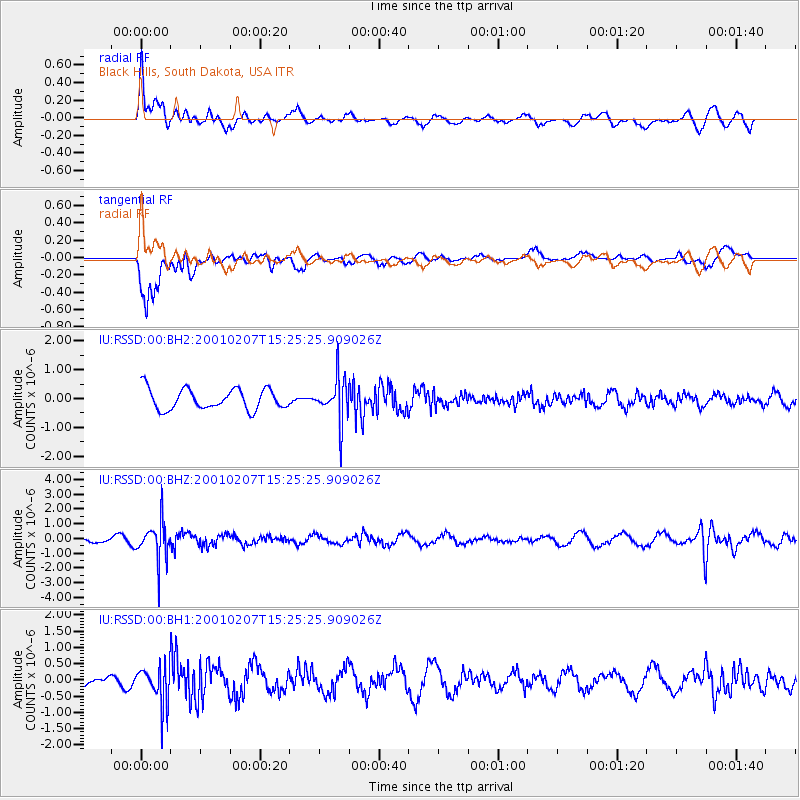
RSSD Black Hills, South Dakota, USA - Earthquake Result Viewer
*The percent match for this event was below the threshold and hence no stack was calculated.
| Earthquake location: |
Northwest Of Kuril Islands |
| Earthquake latitude/longitude: |
52.8/153.8 |
| Earthquake time(UTC): |
2001/02/07 (038) 15:16:15 GMT |
| Earthquake Depth: |
427 km |
| Earthquake Magnitude: |
5.6 MB, 5.8 MW, 5.7 MW |
| Earthquake Catalog/Contributor: |
WHDF/NEIC |
|
| Network: |
IU Global Seismograph Network (GSN - IRIS/USGS) |
| Station: |
RSSD Black Hills, South Dakota, USA |
| Lat/Lon: |
44.12 N/104.04 W |
| Elevation: |
2060 m |
|
| Distance: |
62.7 deg |
| Az: |
52.428 deg |
| Baz: |
318.015 deg |
| Ray Param: |
$rayparam |
*The percent match for this event was below the threshold and hence was not used in the summary stack. |
|
| Radial Match: |
65.79052 % |
| Radial Bump: |
400 |
| Transverse Match: |
78.66734 % |
| Transverse Bump: |
400 |
| SOD ConfigId: |
590571 |
| Insert Time: |
2013-09-24 20:11:32.701 +0000 |
| GWidth: |
2.5 |
| Max Bumps: |
400 |
| Tol: |
0.001 |
|
Signal To Noise
| Channel | StoN | STA | LTA |
| IU:RSSD:00:BHZ:20010207T15:25:25.909026Z | 9.325243 | 1.3475013E-6 | 1.4450039E-7 |
| IU:RSSD:00:BH1:20010207T15:25:25.909026Z | 4.1482215 | 6.131761E-7 | 1.4781664E-7 |
| IU:RSSD:00:BH2:20010207T15:25:25.909026Z | 2.0602186 | 7.394754E-7 | 3.5893055E-7 |
| Arrivals |
| Ps | |
| PpPs | |
| PsPs/PpSs | |


