You are here: Home > Network List > IU - Global Seismograph Network (GSN - IRIS/USGS) Stations List
> Station TEIG Tepich, Yucatan, Mexico > Earthquake Result Viewer
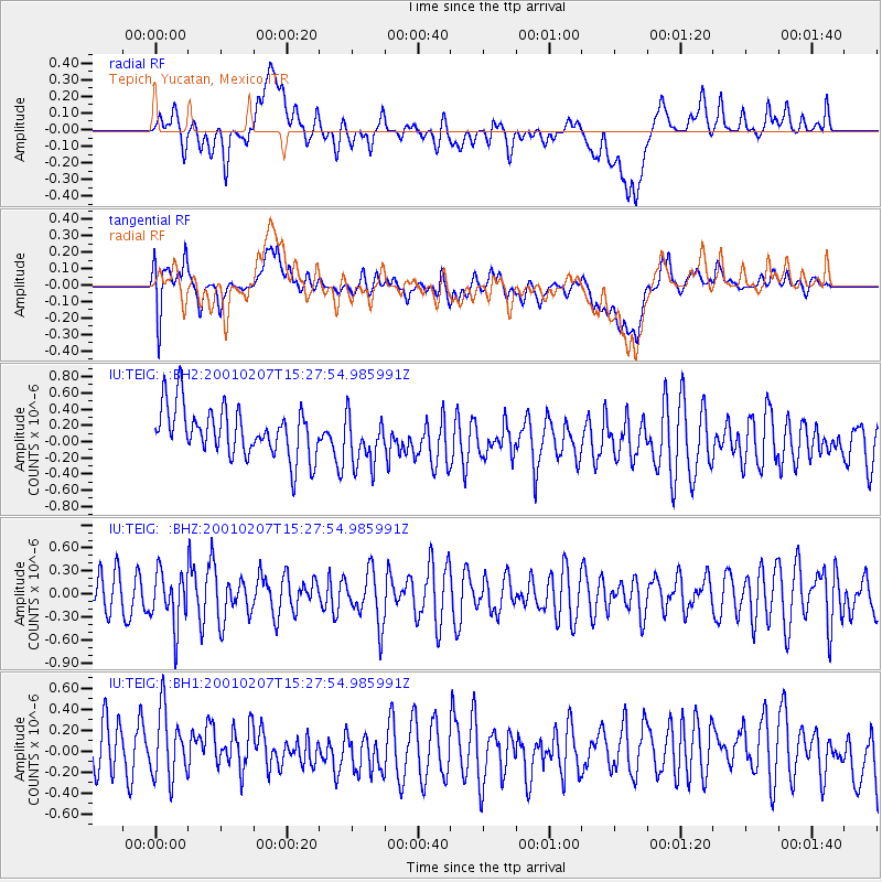
TEIG Tepich, Yucatan, Mexico - Earthquake Result Viewer
*The percent match for this event was below the threshold and hence no stack was calculated.
| Earthquake location: |
Northwest Of Kuril Islands |
| Earthquake latitude/longitude: |
52.8/153.8 |
| Earthquake time(UTC): |
2001/02/07 (038) 15:16:15 GMT |
| Earthquake Depth: |
427 km |
| Earthquake Magnitude: |
5.6 MB, 5.8 MW, 5.7 MW |
| Earthquake Catalog/Contributor: |
WHDF/NEIC |
|
| Network: |
IU Global Seismograph Network (GSN - IRIS/USGS) |
| Station: |
TEIG Tepich, Yucatan, Mexico |
| Lat/Lon: |
20.23 N/88.28 W |
| Elevation: |
69 m |
|
| Distance: |
89.7 deg |
| Az: |
56.112 deg |
| Baz: |
327.498 deg |
| Ray Param: |
$rayparam |
*The percent match for this event was below the threshold and hence was not used in the summary stack. |
|
| Radial Match: |
35.030327 % |
| Radial Bump: |
400 |
| Transverse Match: |
37.078594 % |
| Transverse Bump: |
400 |
| SOD ConfigId: |
590571 |
| Insert Time: |
2013-09-24 20:11:34.299 +0000 |
| GWidth: |
2.5 |
| Max Bumps: |
400 |
| Tol: |
0.001 |
|
Signal To Noise
| Channel | StoN | STA | LTA |
| IU:TEIG: :BHZ:20010207T15:27:54.985991Z | 1.3571471 | 3.5001855E-7 | 2.579076E-7 |
| IU:TEIG: :BH1:20010207T15:27:54.985991Z | 1.2356453 | 4.0668698E-7 | 3.2912925E-7 |
| IU:TEIG: :BH2:20010207T15:27:54.985991Z | 1.0581032 | 3.196928E-7 | 3.0213766E-7 |
| Arrivals |
| Ps | |
| PpPs | |
| PsPs/PpSs | |


