You are here: Home > Network List > IU - Global Seismograph Network (GSN - IRIS/USGS) Stations List
> Station RSSD Black Hills, South Dakota, USA > Earthquake Result Viewer
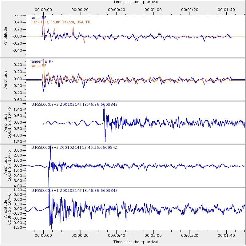
RSSD Black Hills, South Dakota, USA - Earthquake Result Viewer
*The percent match for this event was below the threshold and hence no stack was calculated.
| Earthquake location: |
Kuril Islands |
| Earthquake latitude/longitude: |
48.5/153.3 |
| Earthquake time(UTC): |
2001/02/14 (045) 13:36:39 GMT |
| Earthquake Depth: |
148 km |
| Earthquake Magnitude: |
5.8 MB, 5.6 MW, 5.6 MW |
| Earthquake Catalog/Contributor: |
WHDF/NEIC |
|
| Network: |
IU Global Seismograph Network (GSN - IRIS/USGS) |
| Station: |
RSSD Black Hills, South Dakota, USA |
| Lat/Lon: |
44.12 N/104.04 W |
| Elevation: |
2060 m |
|
| Distance: |
65.6 deg |
| Az: |
50.51 deg |
| Baz: |
314.595 deg |
| Ray Param: |
$rayparam |
*The percent match for this event was below the threshold and hence was not used in the summary stack. |
|
| Radial Match: |
73.71766 % |
| Radial Bump: |
400 |
| Transverse Match: |
75.188065 % |
| Transverse Bump: |
400 |
| SOD ConfigId: |
590571 |
| Insert Time: |
2013-09-24 20:13:44.579 +0000 |
| GWidth: |
2.5 |
| Max Bumps: |
400 |
| Tol: |
0.001 |
|
Signal To Noise
| Channel | StoN | STA | LTA |
| IU:RSSD:00:BHZ:20010214T13:46:36.660984Z | 11.420238 | 1.1614779E-6 | 1.0170348E-7 |
| IU:RSSD:00:BH1:20010214T13:46:36.660984Z | 5.1215086 | 4.445686E-7 | 8.680422E-8 |
| IU:RSSD:00:BH2:20010214T13:46:36.660984Z | 5.2186613 | 5.0576614E-7 | 9.691492E-8 |
| Arrivals |
| Ps | |
| PpPs | |
| PsPs/PpSs | |


